Kiminini land use is a complex mix of residential, commercial, public, and informal development that mirrors the town’s rapid, unplanned growth. Originally built around colonial farms and later subdivided post-independence, Kiminini’s spatial layout lacks formal zoning, with structures and services spreading unevenly. With no approved Local Physical Development Plan, housing estates, markets, institutions, and roads overlap chaotically, affecting infrastructure delivery and urban planning.
As Trans Nzoia’s second-largest town, Kiminini has witnessed a population surge without a proportional increase in services. Housing is now congested in areas like Sokomoko and Muthangari, while neighborhoods like Masaba and Kananachi show better planning and access to utilities. Land is both privately and publicly owned, but the lack of enforcement around designated land use continues to lead to informal settlements, overloaded services, and infrastructure strain.
Main Land Use Types in Kiminini
Land Use Type
Description
Residential
Dominant in Masaba A & B, Sokomoko, Muthangari, and Kananachi
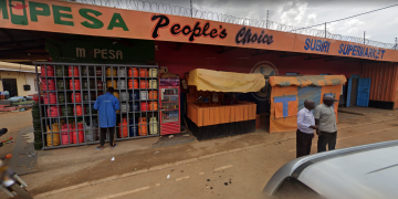
Commercial
Market stalls, shops, fuel stations, small businesses clustered in town center
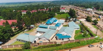
Institutional
Schools, hospitals, churches, administrative offices scattered throughout
Industrial
Small-scale jua kali workshops, slaughterhouse, petrol stations
Public Utility
Bus park, market spaces, and public toilets—limited and often congested
Undeveloped/Open Land
Available plots mostly on town outskirts, with unclear zoning
Commercial and residential plots mixed without plan
Congested Housing in Low-Income Areas
Poor ventilation, poor sanitation, and lack of open space
Inadequate Infrastructure
No sewer system, insufficient piped water, and narrow access roads
Encroachment on Public Spaces
Market overflow, informal structures on roads and drainages
Unapproved Developments
Unregulated housing units increasing fire and safety risks
Recommendations for Sustainable Growth
Action
Benefit
Approve and Implement Development Plan
Guides future land use and housing growth
Upgrade Housing Infrastructure
Enhances quality of life and safety in congested neighborhoods
Introduce Affordable Housing Schemes
Reduces informal settlements and improves sanitation
Formalize Land Ownership and Titles
Enables access to finance and planned development
Create Green Zones and Recreation Areas
Enhances health, aesthetics, and public engagement
Conclusion
The current Kiminini land use setup reveals the consequences of rapid urbanization without structured planning. With rising housing demand, mixed land zoning, and encroachment on public utilities, the town’s future hinges on implementing sustainable land management and infrastructure improvements. A proper development plan, affordable housing policies, and zoning enforcement can transform Kiminini into a balanced and livable town for all residents.
Nyongesa Sande offers diverse content across news, technology, entertainment, and more, aiming to provide readers with a wide range of informative and engaging articles. NYONGESA SANDE's dedicated team provides our audience not only with the highly relevant news but also with outstanding interactive experience.


