
Austronesian people settled the Northern Mariana Islands around 1500 B.C. These people became the indigenous Chamorro and were influenced by later migrations, including Micronesians in the first century A.D. and island Southeast Asians around 900. Spanish explorer Ferdinand MAGELLAN sailed through the Mariana Islands in 1521, and Spain claimed them in 1565. Spain formally colonized the Mariana Islands in 1668 and administered the archipelago from Guam. Spain’s brutal repression of the Chamorro, along with new diseases and intermittent warfare, reduced the indigenous population by about 90% in the 1700s. With a similar dynamic occurring on Guam, Spain forced the Chamorro from the Northern Mariana Islands to resettle there. By the time they returned, many other Micronesians, including Chuukese and Yapese, had already settled on their islands.
In 1898, Spain ceded Guam to the US after the Spanish-American War but sold the Northern Mariana Islands to Germany under the German-Spanish Treaty of 1899. Germany administered the territory from German New Guinea but took a hands-off approach to day-to-day life. Following World War I, Japan administered the islands under a League of Nations mandate. Japan focused on sugar production and brought in thousands of Japanese laborers, who quickly outnumbered the Chamorro on the islands. During World War II, Japan invaded Guam from the Northern Mariana Islands and used Marianan Chamorro as translators with Guamanian Chamorro, creating friction between the two Chamorro communities that continues to this day. The US captured the Northern Mariana Islands in 1944 after the Battle of Saipan and later administered them as part of the Trust Territory of the Pacific Islands (TTPI).
On four occasions in the 1950s and 1960s, voters opted for integration with Guam, which Guam rejected in 1969. In 1978, the Northern Mariana Islands was granted self-governance separate from the rest of the TTPI, and in 1986, islanders were granted US citizenship, with the territory coming under US sovereignty as the Commonwealth of the Northern Mariana Islands (CNMI). In 2009, the CNMI became the final US territory to elect a nonvoting delegate to the US Congress.
Geography
Location
Oceania, islands in the North Pacific Ocean, about three-quarters of the way from Hawaii to the Philippines

Geographic coordinates
15 12 N, 145 45 E
Map references
Oceania
Area
total : 464 sq km
land: 464 sq km
water: 0 sq km
note: consists of 14 islands including Saipan, Rota, and Tinian
comparison ranking: total 196
Area – comparative
2.5 times the size of Washington, D.C.
Land boundaries
total: 0 km
Coastline
1,482 km
Maritime claims
territorial sea: 12 nm
exclusive economic zone: 200 nm
Climate
tropical marine; moderated by northeast trade winds, little seasonal temperature variation; dry season December to June, rainy season July to October
Terrain
the southern islands in this north-south trending archipelago are limestone, with fringing coral reefs; the northern islands are volcanic, with active volcanoes on several islands
Elevation
highest point: Agrihan Volcano 965 m
lowest point: Pacific Ocean 0 m
Natural resources
arable land, fish
Land use
agricultural land: 1.2% (2022 est.)
arable land: 0.2% (2022 est.)
permanent crops: 0.2% (2022 est.)
permanent pasture: 0.8% (2022 est.)
forest: 53% (2022 est.)
other: 45.9% (2022 est.)
Irrigated land
1 sq km (2012)
Population distribution
approximately 90% of the population lives on the island of Saipan
Natural hazards
active volcanoes on Pagan and Agrihan; typhoons (especially August to November)
Geography – note
strategic location in the North Pacific Ocean
People and Society
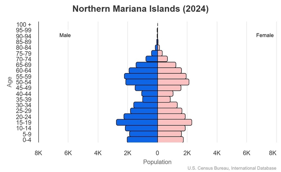
Population
total: 51,118 (2024 est.)
male: 27,044
female: 24,074
comparison rankings: total 209; female 209; male 209
Nationality
noun: NA (US citizens)
adjective: NA
Ethnic groups
Asian 50% (includes Filipino 35.3%, Chinese 6.8%, Korean 4.2%, and other Asian 3.7%), Native Hawaiian or other Pacific Islander 34.9% (includes Chamorro 23.9%, Carolinian 4.6%, and other Native Hawaiian or Pacific Islander 6.4%), other 2.5%, two or more ethnicities or races 12.7% (2010 est.)
Languages
Philippine languages 32.8%, Chamorro (official) 24.1%, English (official) 17%, other Pacific island languages 10.1% (includes Carolinian (official), Chinese 6.8%, other Asian languages 7.3%, other 1.9% (2010 est.)
Religions
Christian (Roman Catholic majority, although traditional beliefs and taboos may still be found)
Age structure
0-14 years: 22.1% (male 6,066/female 5,231)
15-64 years: 67.7% (male 18,206/female 16,377)
65 years and over: 10.2% (2024 est.) (male 2,772/female 2,466)
2024 population pyramid:
Dependency ratios
total dependency ratio: 47.8 (2024 est.)
youth dependency ratio: 32.7 (2024 est.)
elderly dependency ratio: 15.1 (2024 est.)
potential support ratio: 6.6 (2024 est.)
Median age
total: 32.4 years (2024 est.)
male: 31.8 years
female: 33.2 years
comparison ranking: total 116
Population growth rate
-0.34% (2024 est.)
comparison ranking: 214
Birth rate
15.7 births/1,000 population (2024 est.)
comparison ranking: 104
Death rate
5.7 deaths/1,000 population (2024 est.)
comparison ranking: 172
Net migration rate
-13.4 migrant(s)/1,000 population (2024 est.)
comparison ranking: 226
Population distribution
approximately 90% of the population lives on the island of Saipan
Urbanization
urban population: 92.1% of total population (2023)
rate of urbanization: 0.36% annual rate of change (2020-25 est.)
Major urban areas – population
51,000 SAIPAN (capital) (2018)
Sex ratio
at birth: 1.17 male(s)/female
0-14 years: 1.16 male(s)/female
15-64 years: 1.11 male(s)/female
65 years and over: 1.12 male(s)/female
total population: 1.12 male(s)/female (2024 est.)
Infant mortality rate
total: 11.9 deaths/1,000 live births (2024 est.)
male: 14.4 deaths/1,000 live births
female: 9 deaths/1,000 live births
comparison ranking: total 110
Life expectancy at birth
total population: 77.1 years (2024 est.)
male: 75 years
female: 79.5 years
comparison ranking: total population 98
Total fertility rate
2.56 children born/woman (2024 est.)
comparison ranking: 67
Gross reproduction rate
1.18 (2024 est.)
Contraceptive prevalence rate
NA
Drinking water source
improved:
urban: NA
rural: NA
total: 100% of population
unimproved:
urban: NA
rural: NA
total: 0% of population (2020 est.)
Sanitation facility access
improved:
urban: NA
rural: NA
total: 97.9% of population
unimproved:
urban: NA
rural: NA
total: 2.1% of population (2020 est.)
Literacy
total population: NA
male: NA
female: NA
Environment
Environment – current issues
contamination of groundwater on Saipan; clean-up of landfill; protection of endangered species
Climate
tropical marine; moderated by northeast trade winds, little seasonal temperature variation; dry season December to June, rainy season July to October
Land use
agricultural land: 1.2% (2022 est.)
arable land: 0.2% (2022 est.)
permanent crops: 0.2% (2022 est.)
permanent pasture: 0.8% (2022 est.)
forest: 53% (2022 est.)
other: 45.9% (2022 est.)
Urbanization
urban population: 92.1% of total population (2023)
rate of urbanization: 0.36% annual rate of change (2020-25 est.)
Waste and recycling
municipal solid waste generated annually: 32,761 tons (2013 est.)
municipal solid waste recycled annually: 11,794 tons (2016 est.)
percent of municipal solid waste recycled: 36% (2016 est.)
Government
Country name
conventional long form: Commonwealth of the Northern Mariana Islands
conventional short form: Northern Mariana Islands
former: Trust Territory of the Pacific Islands, Mariana Islands District
abbreviation: CNMI
etymology: Spain named the islands in 1667 in honor of the Spanish Queen, MARIANA of Austria
Government type
a commonwealth in political union with and under the sovereignty of the US; republican form of government with separate executive, legislative, and judicial branches
Dependency status
commonwealth in political union with and under the sovereignty of the US; federal funds administered by the US Department of the Interior, Office of Insular Affairs
Capital
name: Saipan
geographic coordinates: 15 12 N, 145 45 E
time difference: UTC+10 (15 hours ahead of Washington, DC, during Standard Time)
etymology: the origin of the name is unclear; it probably comes from a local word meaning “deserted” or “uninhabited,” but stories vary on how it came to be used
Administrative divisions
none (commonwealth in political union with the US); there are no first-order administrative divisions as defined by the US government, but 4 municipalities are considered second-order: Northern Islands, Rota, Saipan, Tinian
Legal system
the laws of the US apply, except for customs and some aspects of taxation
Constitution
history: partially effective 9 January 1978 (Constitution of the Commonwealth of the Northern Mariana Islands); fully effective 4 November 1986 (Covenant Agreement)
amendment process: proposed by constitutional convention, by public petition, or by the Legislature; ratification of proposed amendments requires approval by voters at the next general election or special election; amendments proposed by constitutional convention or by petition become effective if approved by a majority of voters and at least two-thirds majority of voters in each of two senatorial districts; amendments proposed by the Legislature are effective if approved by majority vote
Citizenship
see United States
Suffrage
18 years of age; universal; note – indigenous inhabitants are US citizens but do not vote in US presidential elections
Executive branch
chief of state: President Donald J. TRUMP (since 20 January 2025)
head of government: Governor Arnold PALACIOS (since 9 January 2023)
cabinet: Cabinet appointed by the governor with the advice and consent of the Senate
elections/appointments: president and vice president indirectly elected on the same ballot by an Electoral College of ‘electors’ chosen from each state; president and vice president serve a 4-year term (eligible for a second term); under the US Constitution, residents of the Northern Mariana Islands do not vote in elections for US president and vice president; however, they may vote in Democratic and Republican party presidential primary elections; governor directly elected by absolute majority vote in 2 rounds if needed; election last held on 8 November 2022 with a runoff held on 25 November 2022 (next to be held in 2026)
election results:
2022: Arnold PALACIOS elected governor in second round; percent of vote in first round – Ralph TORRES (Republican) 38.8%; Arnold PALACIOS (independent) 32.2%, Tina SABLAN (Democrat) 28%; percent of vote in second round – Arnold PALACIOS 54%, Ralph TORRES 46%; David APATANG (independent) elected lieutenant governor
2018: Ralph TORRES elected governor; percent of vote – Ralph TORRES (Republican) 62.2%, Juan BABAUTA (independent) 37.8%; Arnold PALACIOS elected lieutenant governor
Legislative branch
note: the Northern Mariana Islands delegate to the US House of Representatives can vote when serving on a committee and when the House meets as the “Committee of the Whole House,” but not when legislation is submitted for a “full floor” House vote
Judicial branch
highest court(s): Supreme Court of the Commonwealth of the Northern Mariana Islands (CNMI) (consists of the chief justice and 2 associate justices); US Federal District Court (consists of 1 judge)
judge selection and term of office: CNMI Supreme Court judges appointed by the governor and confirmed by the CNMI Senate; judges appointed for 8-year terms and another term if directly elected in a popular election; US Federal District Court judges appointed by the US president and confirmed by the US Senate; judges appointed for renewable 10-year terms
subordinate courts: Superior Court
note: US Federal District Court jurisdiction limited to US federal laws; appeals beyond the CNMI Supreme Court are referred to the US Supreme Court
Political parties
Democratic Party
Republican Party
Diplomatic representation from the US
embassy: none (commonwealth in political union with the US)
International organization participation
PIF (observer), SPC, UPU
Independence
none (commonwealth in political union with the US)
National holiday
Commonwealth Day, 8 January (1978)
Flag description
blue with a five-pointed white star on a gray latte stone (a traditional foundation stone) in the center, surrounded by a mwáár or head lei (wreath); blue stands for the Pacific Ocean, the star for the Commonwealth, and the latte stone and mwáár for Marianas culture; the mwáár is made from four kinds of flowers: flores mayo (Plumeria), ylang-ylang or langilang (Cananga odorata), angagha or peacock flower (Caesalpinia pulcherrima), and teibwo or Pacific basil (Ocimum tenuiflorum)
National symbol(s)
latte stone
National colors
blue, white
National anthem
name: “Gi Talo Gi Halom Tasi” (In the Middle of the Sea)
lyrics/music: Jose S. PANGELINAN [Chamoru], David PETER [Carolinian]/Wilhelm GANZHORN
note: adopted 1996; the Carolinian version of the song is known as “Satil Matawal Pacifico;” as a commonwealth of the US, in addition to the local anthem, “The Star-Spangled Banner” is official (see United States)
Economy
Economic overview
US Pacific island commonwealth economy; growing Chinese and Korean tourist destination; hit hard by 2018 typhoon; dependent on energy imports; exempt from some US labor and immigration laws; longstanding garment production
Real GDP (purchasing power parity)
$1.242 billion (2016 est.)
$933 million (2015 est.)
$845 million (2014 est.)
note: GDP estimate includes US subsidy; data are in 2013 dollars
comparison ranking: 207
Real GDP growth rate
16.64% (2022 est.)
4.97% (2021 est.)
-29.68% (2020 est.)
note: annual GDP % growth based on constant local currency
comparison ranking: 4
Real GDP per capita
$24,500 (2016 est.)
$18,400 (2015 est.)
$16,600 (2014 est.)
comparison ranking: 89
GDP (official exchange rate)
$1.096 billion (2022 est.)
note: data in current dollars at official exchange rate
Inflation rate (consumer prices)
0.3% (2016 est.)
0.1% (2015 est.)
comparison ranking: 13
GDP – composition, by sector of origin
agriculture: 1.7% (2016)
industry: 58.1% (2016 est.)
services: 40.2% (2016)
comparison rankings: services 196; industry 6; agriculture 168
GDP – composition, by end use
household consumption: 66.2% (2022 est.)
government consumption: 28.9% (2016 est.)
investment in fixed capital: 26.3% (2016 est.)
exports of goods and services: 22.3% (2022 est.)
imports of goods and services: -70.9% (2022 est.)
note: figures may not total 100% due to rounding or gaps in data collection
Agricultural products
vegetables and melons, fruits and nuts; ornamental plants; livestock, poultry, eggs; fish and aquaculture products
Industries
tourism, banking, construction, fishing, handicrafts, other services
Industrial production growth rate
4.3% (2014 est.)
note: annual % change in industrial value added based on constant local currency
comparison ranking: 64
Budget
revenues: $389.6 million (2016 est.)
expenditures: $344 million (2015 est.)
Public debt
7.1% of GDP (2017 est.)
comparison ranking: 197
Taxes and other revenues
31.4% (of GDP) (2016 est.)
comparison ranking: 20
Exports
$244 million (2022 est.)
$55 million (2021 est.)
$128 million (2020 est.)
note: GDP expenditure basis – exports of goods and services in current dollars
comparison ranking: 202
Exports – partners
Sweden 21%, Singapore 20%, Hong Kong 12%, UK 8%, India 7% (2023)
note: top five export partners based on percentage share of exports
Exports – commodities
scrap iron, refined petroleum, scrap copper, hydraulic engines, integrated circuits (2021)
top five export commodities based on value in dollars
Imports
$777 million (2022 est.)
$666 million (2021 est.)
$556 million (2020 est.)
note: GDP expenditure basis – imports of goods and services in current dollars
comparison ranking: 196
Imports – partners
Singapore 63%, Japan 12%, Hong Kong 8%, Taiwan 4%, Philippines 3% (2023)
note: top five import partners based on percentage share of imports
Imports – commodities
refined petroleum, cars, jewelry, trunks and cases, flavored water (2023)
Exchange rates
the US dollar is used
Energy
Electricity access
electrification – total population: 100% (2022 est.)
Energy consumption per capita
(2019)
Communications
Telephones – fixed lines
total subscriptions: 20,000 (2021 est.)
subscriptions per 100 inhabitants: 42 (2022 est.)
comparison ranking: total subscriptions 172
Telephones – mobile cellular
total subscriptions: 20,474 (2004 est.)
subscriptions per 100 inhabitants: 28 (2004)
comparison ranking: total subscriptions 216
Broadcast media
1 TV station on Saipan; multi-channel cable TV services are available on Saipan; 9 licensed radio stations (2009)
Internet country code
.mp
Internet users
percent of population: 25.1% (2021 est.)
Transportation
Airports
4 (2025)
comparison ranking: 183
Heliports
7 (2025)
comparison ranking: 89
Ports
total ports: 3 (2024)
large: 0
medium: 0
small: 1
very small: 2
ports with oil terminals: 1
key ports: Rota, Saipan, Tinian
Military and Security
Military – note
defense is the responsibility of the US


