A large body of recent oceanographic research has shown that the Antarctic Circumpolar Current (ACC), an ocean current that flows from west to east around Antarctica, plays a crucial role in global ocean circulation. The region where the cold waters of the ACC meet and mingle with the warmer waters of the north defines a distinct border — the Antarctic Convergence — which fluctuates with the seasons but encompasses a discrete body of water and a unique ecologic region. The Convergence concentrates nutrients, which promotes marine plant life, which in turn allows for a greater abundance of animal life. In 2000, the International Hydrographic Organization delimited the waters within the Convergence as a fifth world ocean basin — the Southern Ocean — by combining the southern portions of the Atlantic Ocean, Indian Ocean, and Pacific Ocean. The Southern Ocean extends from the coast of Antarctica north to 60 degrees south latitude, which coincides with the Antarctic Treaty region and which approximates the extent of the Antarctic Convergence. As such, the Southern Ocean is now the fourth largest of the world’s five ocean basins (after the Pacific Ocean, Atlantic Ocean, and Indian Ocean). It should be noted that inclusion of the Southern Ocean does not imply US Government recognition of this feature as one of the world’s primary ocean basins.
Geography
Location
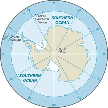
body of water between 60 degrees south latitude and Antarctica
Geographic coordinates
60 00 S, 90 00 E (nominally), but the Southern Ocean has the unique distinction of being a large circumpolar body of water totally encircling the continent of Antarctica; this ring of water lies between 60 degrees south latitude and the coast of Antarctica and encompasses 360 degrees of longitude
Map references
Antarctic Region
Area
total : 21.96 million sq km
note: includes Amundsen Sea, Bellingshausen Sea, part of the Drake Passage, Ross Sea, a small part of the Scotia Sea, Weddell Sea, and other tributary water bodies
Area – comparative
slightly more than twice the size of the US
Coastline
17,968 km
Climate
sea temperatures vary from about 10 degrees Celsius to -2 degrees Celsius; cyclonic storms travel eastward around the continent and frequently are intense because of the temperature contrast between ice and open ocean; the ocean area from about latitude 40 south to the Antarctic Circle has the strongest average winds found anywhere on Earth; in winter the ocean freezes outward to 65 degrees south latitude in the Pacific sector and 55 degrees south latitude in the Atlantic sector, lowering surface temperatures well below 0 degrees Celsius; at some coastal points intense persistent drainage winds from the interior keep the shoreline ice-free throughout the winter
Ocean volume
ocean volume: 71.8 million cu km
percent of World Ocean total volume: 5.4%
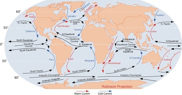
Major ocean currents
the cold, clockwise-flowing Antarctic Circumpolar Current (West Wind Drift; 21,000 km long) moves perpetually eastward around the continent and is the world’s largest and strongest ocean current, transporting 130 million cubic meters of water per second – 100 times the flow of all the world’s rivers; it is also the only current that flows all the way around the planet and connects the Atlantic, Pacific, and Indian Ocean basins; the cold Antarctic Coastal Current (East Wind Drift) is the southernmost current in the world, flowing westward and parallel to the Antarctic coastline
Major World Ocean Currents:
Bathymetry
continental shelf: the following are examples of features found on the continental shelf of the Southern Ocean (see Figure 2):
Astrid Ridge (see also Figure 4)
Belgrano Bank
Gunnerus Ridge (see also Figure 4)
Hayes Bank
Iselin Bank
continental slope: the following are examples of features found on the continental slope of the Southern Ocean (see Figure 2):
Amery Basin (Figure 4)
Filchner Trough
Hillary Canyon
Pobeda Canyon (Figure 3)
abyssal plains: the following are examples of features found on the abyssal plains of the Southern Ocean (see Figures 2, 3, and 4):
Amundsen (Abyssal) Plain
Enderby (Abyssal) Plain
South Indian/Australian-Antarctic Basin
Southeast Pacific/Bellinghausen Basin
Weddell (Abyssal) Plain
mid-ocean ridge: the following are examples of mid-ocean ridges found on the floor of the Southern Ocean (see Figure 2):
Pacific-Antarctic Ridge (Figure 3)
undersea terrain features: the following are examples of undersea terrain features found on the floor of the Southern Ocean (see Figure 2):
Akopov Seamounts (Figure 3)
De Gerlache Seamounts (see also Figure 3, 4)
Endurance Ridge (Figure 4)
Marie Byrd Seamount (see also Figure 3)
Maud Rise (see also Figure 4)
Scott Seamounts (see also Figure 3)
ocean trenches:
the following are examples of ocean trenches found on the floor of the Southern Ocean (see Figure 2):
South Sandwich Trench (Figure 4; the deepest location in the Southern Ocean)
atolls: due to the extremely cold water, there are no atolls in the Southern Ocean
Figure 1. Profile of the sea floor:
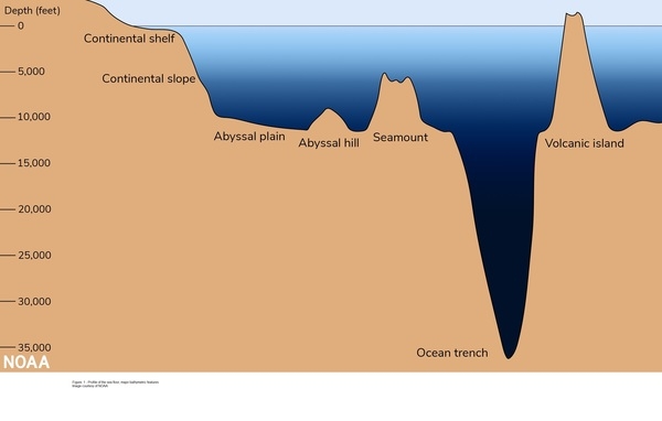
Figure 2. Southern Ocean:

Figure 3. Antarctica – Pacific Ocean view:

Figure 4. Antarctica – Atlantic and Indian Ocean view:

Elevation
highest point: sea level
lowest point: southern end of the South Sandwich Trench -7,434 m unnamed deep
mean depth: -3,270 m
ocean zones: Composed of water and in a fluid state, the ocean is delimited differently than the solid continents. It is divided into three zones based on depth and light level. Sunlight entering the water may travel about 1,000 m into the oceans under the right conditions, but there is rarely any significant light beyond 200 m.
The upper 200 m (656 ft) of the ocean is called the euphotic, or “sunlight,” zone. This zone contains the vast majority of commercial fisheries and is home to many protected marine mammals and sea turtles. Only a small amount of light penetrates beyond this depth.
The zone between 200 m (656 ft) and 1,000 m (3,280 ft) is usually referred to as the “twilight” zone, but is officially the dysphotic zone. In this zone, the intensity of light rapidly dissipates as depth increases. Such a minuscule amount of light penetrates beyond a depth of 200 m that photosynthesis is no longer possible.
The aphotic, or “midnight,” zone exists in depths below 1,000 m (3,280 ft). Sunlight does not penetrate to these depths, and the zone is bathed in darkness.
Distance Sunlight Travels in the Ocean:

Natural resources
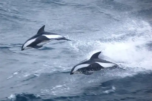
probable large oil and gas fields on the continental margin; manganese nodules, possible placer deposits, sand and gravel, fresh water as icebergs; krill, fish
Natural hazards
huge icebergs with drafts up to several hundred meters; smaller bergs and iceberg fragments; sea ice (generally 0.5 to 1 m thick) with sometimes dynamic short-term variations and with large annual and interannual variations; deep continental shelf floored by glacial deposits varying widely over short distances; high winds and large waves much of the year; ship icing, especially May-October; most of region is remote from sources of search and rescue
Geography – note
the major chokepoint is the Drake Passage between South America and Antarctica; the Polar Front (Antarctic Convergence) is the best natural definition of the northern extent of the Southern Ocean; it is a distinct region at the middle of the Antarctic Circumpolar Current that separates the cold polar surface waters to the south from the warmer waters to the north; the Front and the Current extend entirely around Antarctica, reaching south of 60 degrees south near New Zealand and near 48 degrees south in the far South Atlantic, coinciding with the path of the maximum westerly winds
Environment
Environment – current issues
natural and man-made changes to the ocean’s physical, chemical, and biological systems
Environment – international agreements
the Southern Ocean is subject to all international agreements regarding the world’s oceans; in addition, it is subject to these agreements specific to the Antarctic region: International Whaling Commission (prohibits commercial whaling south of 40 degrees south [south of 60 degrees south between 50 degrees and 130 degrees west]); Convention on the Conservation of Antarctic Seals (limits sealing); Convention on the Conservation of Antarctic Marine Living Resources (regulates fishing)
note: mineral exploitation except for scientific research is banned by the Environmental Protocol to the Antarctic Treaty; additionally, many nations (including the US) prohibit mineral resource exploration and exploitation south of the fluctuating Polar Front (Antarctic Convergence), which is in the middle of the Antarctic Circumpolar Current and serves as the dividing line between the cold polar surface waters to the south and the warmer waters to the north
Climate
sea temperatures vary from about 10 degrees Celsius to -2 degrees Celsius; cyclonic storms travel eastward around the continent and frequently are intense because of the temperature contrast between ice and open ocean; the ocean area from about latitude 40 south to the Antarctic Circle has the strongest average winds found anywhere on Earth; in winter the ocean freezes outward to 65 degrees south latitude in the Pacific sector and 55 degrees south latitude in the Atlantic sector, lowering surface temperatures well below 0 degrees Celsius; at some coastal points intense persistent drainage winds from the interior keep the shoreline ice-free throughout the winter
Marine fisheries
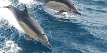
the Southern Ocean fishery is relatively small with a total catch of 388,901 mt in 2021; the Food and Agriculture Organization has delineated three regions in the Southern Ocean (Regions 48, 58, 88) that generally encompass the waters south of 40° to 60° South latitude; the most important producers in these regions include Norway (241,408 mt), China (47,605 mt), and South Korea (39,487 mt); Antarctic krill made up 95.5% of the total catch in 2021, while other important species include Patagonian and Antarctic toothfish
Regional fisheries bodies: Commission for the Conservation of Antarctic Marine Living ResourcesFAO map of world fishing regions; used with permission.
Government
Country name
etymology: the International Hydrographic Organization (IHO) has not formally adopted the definition of the Southern Ocean as the waters south of 60 degrees south; the definition, however, was circulated in a draft edition of the IHO’s Names and Limits of Oceans and Seas in 2002 and has since become the de facto name for many nations and organizations, including the CIA
Transportation
Transportation – note
Drake Passage offers alternative to transit through the Panama Canal


