
Polynesians lived on Norfolk Island between 1200 and 1500, but the remote island was uninhabited by the time British explorer James COOK landed on the island in 1774. Two British attempts at establishing the island as a penal colony (1788-1814 and 1825-55) were ultimately abandoned.
In 1856, almost 200 Pitcairn Islanders — descendants of the Bounty mutineers and their Tahitian companions — were relocated to Norfolk Island because of overcrowding on the Pitcairn Islands. Some returned to the Pitcairn Islands over the next few years, but most settled permanently on Norfolk Island and recreated their previous land tenure and governance structures. Norfolk Island retained a great degree of local control until 1897, when it became a dependency of New South Wales. During World War II, Norfolk Island was an airbase and an important refueling stop in the South Pacific. In 1976, an Australian judge recommended Norfolk Island be incorporated fully into Australia, which Norfolk Islanders rejected. After an appeal to the UN, Australia granted limited self-government to Norfolk Island in 1979.
With growing financial troubles during the 2000s, Australia abolished the Norfolk Island Legislative Assembly in 2015, reduced Norfolk Island’s autonomy in 2016, and suspended the local council in 2020. Most services are provided by a mix of the Australian Capital Territory and the states of New South Wales and Queensland. These moves were unpopular on Norfolk Island, which has sought to have its self-government restored and as of 2024, the Australian Government was working with Norfolk Island to establish a new local governing body.
Geography
Location
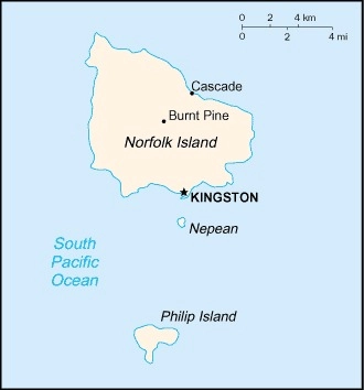
Oceania, island in the South Pacific Ocean, east of Australia
Geographic coordinates
29 02 S, 167 57 E
Map references
Oceania
Area
total : 36 sq km
land: 36 sq km
water: 0 sq km
comparison ranking: total 233
Area – comparative
about 0.2 times the size of Washington, D.C.
Land boundaries
total: 0 km
Coastline
32 km
Maritime claims
territorial sea: 12 nm
contiguous zone: 24 nm
exclusive fishing zone: 200 nm
Climate
subtropical; mild, little seasonal temperature variation
Terrain
volcanic island with mostly rolling plains
Elevation
highest point: Mount Bates 319 m
lowest point: Pacific Ocean 0 m
Natural resources
fish
Land use
agricultural land: 25% (2022 est.)
arable land: 0% (2022 est.)
permanent crops: 0% (2022 est.)
permanent pasture: 25% (2022 est.)
forest: 12.3% (2022 est.)
other: 62.8% (2022 est.)
Irrigated land
0 sq km (2022)
Population distribution
population concentrated around the capital of Kingston
Natural hazards
tropical cyclones (especially May to July)
Geography – note
most of the 32-km (20-mi) coastline consists of almost inaccessible cliffs, but the land slopes down to the sea in one small southern area on Sydney Bay, where the capital of Kingston is located
People and Society
Population
total: 1,739 (2021)
male: 823
female: 916
comparison rankings: total 233; female 232; male 233
Nationality
noun: Norfolk Islander(s)
adjective: Norfolk Islander(s)
Ethnic groups
Australian 22.8%, English 22.4%, Pitcairn Islander 20%, Scottish 6%, Irish 5.2%(2011 est.)
note: respondents were able to identify up to two ancestries; percentages represent a proportion of all responses from people in Norfolk Island, including those who did not identify an ancestry; only top responses are shown
Languages
English (official) 44.9%, Norfolk (official, a mixture of 18th century English and ancient Tahitian) 40.3%, Fijian 1.8%, other 6.8%, unspecified 6.2% (2016 est.)
note: data represent language spoken at home
Religions
Protestant 46.8% (Anglican 29.2%, Uniting Church in Australia 9.8%, Presbyterian 2.9%, Seventh Day Adventist 2.7%, other 2.2%), Roman Catholic 12.6%, other Christian 2.9%, other 1.4%, none 26.7%, unspecified 9.5% (2016 est.)
Population growth rate
0.01% (2014 est.)
comparison ranking: 192
Population distribution
population concentrated around the capital of Kingston
Environment
Environment – current issues
inadequate solid-waste management; most freshwater obtained through rainwater catchment; preservation of unique ecosystem
Climate
subtropical; mild, little seasonal temperature variation
Land use
agricultural land: 25% (2022 est.)
arable land: 0% (2022 est.)
permanent crops: 0% (2022 est.)
permanent pasture: 25% (2022 est.)
forest: 12.3% (2022 est.)
other: 62.8% (2022 est.)
Government
Country name
conventional long form: Territory of Norfolk Island
conventional short form: Norfolk Island
etymology: named by British explorer Captain James COOK after Edward HOWARD, the ninth Duke of Norfolk, in 1774
Government type
non-self-governing overseas territory of Australia; note – the Norfolk Island Regional Council, which began operations 1 July 2016, is responsible for planning and managing a variety of public services, including those funded by the Government of Australia
Dependency status
self-governing territory of Australia; administered from Canberra by the Department of Infrastructure, Transport, Cities, & Regional Development
Capital
name: Kingston
geographic coordinates: 29 03 S, 167 58 E
time difference: UTC+11 (16 hours ahead of Washington, DC, during Standard Time)
daylight saving time: +1hr, begins first Sunday in October; ends first Sunday in April
etymology: the name blends the words “king’s” and “town;” the English king at the time of the town’s settlement in the late 18th century was GEORGE III
Administrative divisions
none (territory of Australia)
Legal system
English common law and the laws of Australia
Constitution
history: previous 1913, 1957; latest effective 7 August 1979
Citizenship
see Australia
Suffrage
18 years of age; universal
Executive branch
chief of state: King CHARLES III (since 8 September 2022); represented by Governor General of the Commonwealth of Australia General David HURLEY (since 1 July 2019)
head of government: Administrator Eric HUTCHINSON (since 1 April 2017)
cabinet: Executive Council consists of 4 Legislative Assembly members
elections/appointments: the monarchy is hereditary; governor general appointed by the monarch; administrator appointed by the governor general of Australia for a 2-year term and represents the monarch and Australia
Legislative branch
legislature name: Norfolk Island Regional Council
legislative structure: unicameral
number of seats: 5 (directly elected)
electoral system: plurality/majority
scope of elections: full renewal
term in office: 4 years
most recent election date: 5/28/2016
parties elected and seats per party: independent (5)
percentage of women in chamber: 20%
expected date of next election: March 2021 (postponed)
Judicial branch
highest court(s): Supreme Court of Norfolk Island (consists of the chief justice and several justices)
judge selection and term of office: justices appointed by the governor general of Australia from among justices of the Federal Court of Australia; justices serve until mandatory retirement at age 70
subordinate courts: Petty Court of Sessions; specialized courts, including a Coroner’s Court and the Employment Tribunal
note: appeals beyond the Supreme Court of Norfolk Island are heard by the Federal Court and the High Court of Australia
Political parties
Norfolk Island Labor Party
Norfolk Liberals
Diplomatic representation in the US
none (territory of Australia)
Diplomatic representation from the US
embassy: none (territory of Australia)
International organization participation
UPU
Independence
none (territory of Australia)
National holiday
Bounty Day (commemorates the arrival of Pitcairn Islanders), 8 June (1856)
Flag description
three vertical bands of green (hoist side), white, and green, with a large green Norfolk Island pine tree centered in the white band; green stands for the island’s rich vegetation, and the native pine tree is an island symbol
note: resembles Canada’s flag in its use of only two colors and depiction of a local floral symbol in the central white band; also resembles Nigeria’s green-and-white triband
National symbol(s)
Norfolk Island pine
National coat of arms
Norfolk Island is part of the Commonwealth of Australia, and in 1980, Queen Elizabeth II granted it a separate coat of arms (pictured); in the center is the island’s symbol, the Norfolk Island Pine, with Britain’s lion and Australia’s kangaroo supporting the shield; the island’s motto, “Inasmuch,” comes from a verse in the Bible’s Gospel of Matthew

National anthem
name: “Come Ye Blessed”
lyrics/music: New Testament/John Prindle SCOTT
note: the local anthem, whose lyrics consist of the words from Matthew 25:34-36, 40, is also known as “The Pitcairn Anthem;” the island does not recognize “Advance Australia Fair” (which other Australian territories use); instead “God Save the King” is official (see United Kingdom)
Economy
Economic overview
high-income Australian territorial economy; key tourism and re-exportation industries; small labor force and declining participation creating more part-time jobs; former tax haven; increasing medical cannabis exporter; little transportation infrastructure
Agricultural products
Norfolk Island pine seed, Kentia palm seed, cereals, vegetables, fruit; cattle, poultry
Industries
tourism, light industry, ready mixed concrete
Exports – partners
USA 31%, Belgium 9%, Philippines 7%, Israel 6%, Singapore 6% (2023)
note: top five export partners based on percentage share of exports
Exports – commodities
pine seeds, lumber, cars and vehicle parts, soybeans, lactose syrup (2021)
top five export commodities based on value in dollars
Imports – partners
Australia 52%, Fiji 13%, NZ 12%, Saudi Arabia 12%, Malaysia 5% (2023)
note: top five import partners based on percentage share of imports
Imports – commodities
refined petroleum, plastics, electrical lighting/signalling equipment, cars, machinery (2023)
Exchange rates
Australian dollars (AUD) per US dollar –
Exchange rates:
1.505 (2023 est.)
1.442 (2022 est.)
1.331 (2021 est.)
1.453 (2020 est.)
1.439 (2019 est.)
Communications
Broadcast media
1 local radio station; broadcasts of several Australian radio and TV stations available via satellite (2009)
Internet country code
.nf
Internet users
percent of population: 46.1% (2021 est.)
Transportation
Airports
1 (2025)
comparison ranking: 216
Ports
total ports: 1 (2024)
large: 0
medium: 0
small: 0
very small: 1
ports with oil terminals: 1
key ports: Kingston
Military and Security
Military – note
defense is the responsibility of Australia


