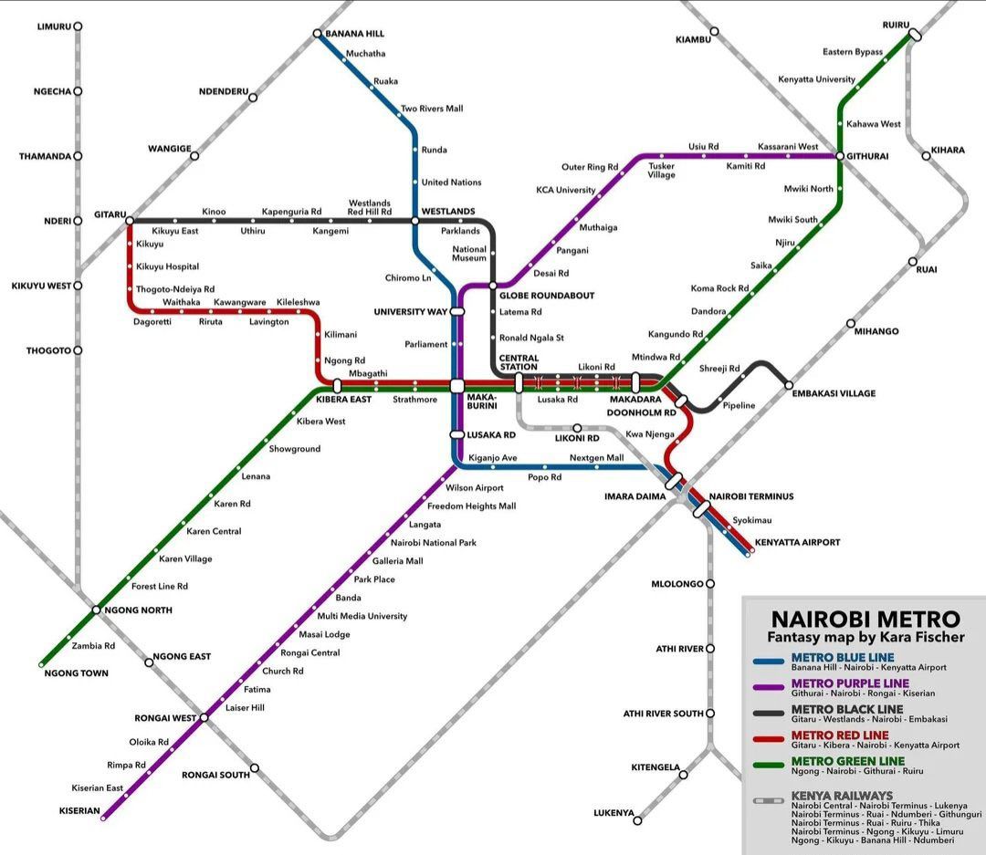
The Nairobi Metro Project is an ambitious vision to reshape urban mobility in Kenya’s capital. Designed as a conceptual fantasy map by urban planner Kara Fischer, it imagines a modern metro system connecting Nairobi’s Central Business District (CBD) to its sprawling suburbs, industrial zones, and the international airport.
This project, though not officially sanctioned, highlights the urgent need for mass rapid transit in one of Africa’s fastest-growing cities. With Nairobi’s population projected to exceed 7 million by 2030, such a metro system could radically improve commuting, reduce traffic congestion, and foster economic growth.
The Metro Lines
The fantasy map envisions six key metro lines, each designed to serve major urban and suburban corridors:
- Metro Blue Line (Banana Hill – Nairobi – Kenyatta Airport)
- Starts in Banana Hill, passes Ruaka, Two Rivers Mall, Westlands, University Way, and Central Station.
- Extends south through Industrial Area, Imara Daima, and Nairobi Terminus to Jomo Kenyatta International Airport.
- Provides a direct link between residential suburbs, the CBD, and the airport — crucial for business and tourism.
- Metro Purple Line (Githurai – Nairobi – Rongai – Kiserian)
- Runs from Githurai through Kasarani, Globe Roundabout, Central Station, and Strathmore University.
- Extends south via Rongai, Laiser Hill, Fatima, and ends in Kiserian.
- Serves commuters from Nairobi’s densely populated eastern and southern suburbs.
- Metro Black Line (Gitaru – Westlands – Nairobi – Embakasi Village)
- Connects western neighborhoods like Kinoo, Kangemi, and Kileleshwa with Nairobi CBD.
- Passes through Globe Roundabout, Central Station, and Industrial Area, before reaching Pipeline and Embakasi Village.
- Ideal for linking residential areas with industrial and commercial employment hubs.
- Metro Red Line (Kikuyu – Kileleshwa – Nairobi – Kenyatta Airport)
- Starts from Kikuyu, linking Dagoretti, Kawangware, Kilimani, and Ngong Road.
- Passes through Parliament, Central Station, Lusaka Road, and Airport South.
- Offers a direct alternative route to JKIA from Nairobi’s western suburbs.
- Metro Green Line (Ngong – Kibera – Nairobi – Ruiru)
- Begins in Ngong Town, through Karen, Lenana, Kibera East, and Strathmore.
- Cuts across Central Station before heading northeast via Outer Ring Road, Dandora, and ending in Ruiru.
- Serves Nairobi’s most populous belt, including Kibera, Eastlands, and Thika Road communities.
- Kenya Railways Grey Line (Commuter Rail Integration)
- Integrates existing Kenya Railways commuter services.
- Links Nairobi Central with Thika, Kikuyu, Ngong, Limuru, and Athi River.
- Ensures the metro system complements current national and suburban rail infrastructure.
Key Hubs and Interchanges
Several stations act as interchange points, making transfers smooth and efficient:
- Central Station – Main hub connecting all lines, mirroring global metro systems.
- Globe Roundabout – A major convergence point for Purple, Black, and Green lines.
- Makadara & Imara Daima – Key southern junctions with links to commuter rail and Nairobi Terminus.
- Airport Stations (JKIA & Wilson) – Ensure seamless business and tourism connectivity.
Economic and Social Impact
The Nairobi Metro Project, if realized, would transform how people live and work:
- Reduced Congestion: By diverting commuters from roads, it would ease traffic jams that cost Nairobi billions annually.
- Affordable Mobility: Linking informal settlements and middle-class suburbs to the CBD makes transport accessible.
- Boost to Real Estate: Areas like Karen, Kikuyu, and Ruiru would see property values rise due to improved connectivity.
- Sustainability: A metro system would cut vehicle emissions, aligning with Kenya’s climate goals.
- Job Creation: Construction, maintenance, and operations would generate thousands of employment opportunities.
Challenges and Considerations
Despite its promise, the Nairobi Metro Project faces several hurdles:
- High Costs: Such infrastructure requires billions of dollars in investment.
- Land Acquisition: Many routes cut through densely populated or built-up areas.
- Policy and Governance: Coordination between national and county governments would be critical.
- Public Buy-In: Success depends on affordability and widespread adoption by commuters.
Conclusion
While still a fantasy concept, the Nairobi Metro Project sparks necessary conversations about the city’s transport future. Nairobi urgently needs efficient, modern transit solutions to match its rapid growth. Whether this exact vision materializes or inspires a modified plan, one thing is clear: a metro system could redefine Nairobi’s urban landscape for generations.


