Nyongesa Sande
No Result
View All Result
  • News
    • World
    • Africa
  • Politics
  • Business
  • Tech
  • AI
  • Telecom
  • Sports
  • Opinion
  • Lifestyle
  • Live
  • World Cup 2026
    • World Cup 2026 Standings
    • World Cup 2026
Nyongesa Sande
  • About Us
    • Nyosake Designers
      • Nyosake Webmasters
      • Nyosake Investment
  • Contact Us
    • Newsroom Contact
  • Ownership Disclosure
  • Advertise
No Result
View All Result
Nyongesa Sande
No Result
View All Result
  • News
  • Politics
  • Business
  • Tech
  • AI
  • Telecom
  • Sports
  • Opinion
  • Lifestyle
  • Live
  • World Cup 2026
ADVERTISEMENT

Home » Ashmore and Cartier Islands

Ashmore and Cartier Islands

NyongesaSande News Desk by NyongesaSande News Desk
12 months ago
in CIA World Factbook
Reading Time: 6 mins read
A A
Flag of Australia

Flag of Australia

Indonesian fishermen have long fished in the area around Ashmore Reef and Cartier Island. British explorers were the first Europeans to see Cartier Island and Ashmore Reef in 1800 and 1811, respectively. American whalers frequently sailed by the islands in the 1850s and later settled to mine the phosphate deposits on Ashmore Reef, which were exhausted by 1891. The UK disputed US access to Ashmore Reef and formally annexed it in 1878. Cartier Island was annexed in 1909. In 1931, the UK transferred the islands to Australia, which accepted them in 1934 as part of Western Australia. In 1938, Australia transferred governance to the Northern Territory. During World War II, Cartier Island was used as a bombing range. In 1978, governance of Ashmore and Cartier Islands was moved to the federal government. Ashmore Reef and Cartier Island became marine reserves in 1983 and 2000 respectively.

  • Geography
    • Location
    • Geographic coordinates
    • Map references
    • Area
    • Area – comparative
    • Land boundaries
    • Coastline
    • Maritime claims
    • Climate
    • Terrain
    • Elevation
    • Natural resources
    • Land use
    • Natural hazards
    • Geography – note
  • People and Society
    • Population
  • Environment
    • Environment – current issues
    • Climate
    • Land use
  • Government
    • Country name
    • Dependency status
    • Legal system
    • Citizenship
    • Diplomatic representation in the US
    • Diplomatic representation from the US
    • Flag description
  • Military and Security
    • Military – note
  • Transnational Issues
    • Illicit drugs

In 1974, Australia and Indonesia signed a memorandum of understanding (MOU) to allow Indonesian fishermen to continue fishing around the islands. The MOU also allows Indonesian fishermen to visit the graves of past fishermen, replenish their fresh water, and shelter in the West Island Lagoon of Ashmore Reef. In the 1990s, Indonesia challenged Australia’s claim to the islands, which was settled in a maritime boundary treaty in 1997. The islands were a popular first point of contact for migrants and refugees seeking to enter Australia, so in 2001, Australia declared the islands to be outside the Australian migration zone.

Geography

Location

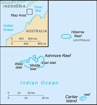
Southeastern Asia, islands in the Indian Ocean, midway between northwestern Australia and Timor island; Ashmore Reef is 840 km west of Darwin and 610 km north of Broome; Cartier Islet is 70 km east of Ashmore Reef

ADVERTISEMENT
Ashmore and Cartier Islands map

Geographic coordinates

12 25 S, 123 20 E

note – Ashmore Reef – 12 14 S, 123 05 E; Cartier Islet – 12 32 S, 123 32 E

Map references

Southeast Asia

ADVERTISEMENT

Area

total : 5 sq km

land: 5 sq km

water: 0 sq km

note: includes Ashmore Reef (West, Middle, and East Islets) and Cartier Island

comparison ranking: total 245

Area – comparative

about eight times the size of the National Mall in Washington, D.C.

ADVERTISEMENT

Land boundaries

total: 0 km

Coastline

74.1 km

Maritime claims

territorial sea: 12 nm

contiguous zone: 24 nm

continental shelf: 200-m depth or to the depth of exploitation

exclusive fishing zone: 200 nm

Climate

tropical

Terrain

low with sand and coral

Elevation

highest point: Cartier Island 5 m

lowest point: Indian Ocean 0 m

Natural resources

fish

Land use

agricultural land: 0% (2018 est.)

Natural hazards

surrounded by shoals and reefs that can pose maritime hazards

Geography – note

Ashmore Reef National Nature Reserve established in 1983; Cartier Island Marine Reserve established in 2000

People and Society

Population

total: no permanent inhabitants

note: Indonesian fishermen are allowed access to the lagoon and fresh water at Ashmore Reef’s West Island; access to East and Middle Islands is by permit only

Environment

Environment – current issues

illegal killing of protected wildlife; overfishing; sea-level rise, changes in sea temperature, and ocean acidification; marine debris

Climate

tropical

Land use

agricultural land: 0% (2018 est.)

Government

Country name

conventional long form: Territory of Ashmore and Cartier Islands

conventional short form: Ashmore and Cartier Islands

etymology: named after British Captain Samuel ASHMORE, who first sighted the island in 1811, and after the ship Cartier, from which the second island was discovered in 1800

Dependency status

territory of Australia; administered from Canberra by the Department of Regional Australia, Local Government, Arts and Sport

Legal system

the laws of the Commonwealth of Australia and the laws of the Northern Territory of Australia, where applicable, apply

Citizenship

see Australia

Diplomatic representation in the US

none (territory of Australia)

Diplomatic representation from the US

embassy: none (territory of Australia)

Flag description

the flag of Australia is used

Military and Security

Military – note

defense is the responsibility of Australia

Transnational Issues

Illicit drugs

NA

ShareTweetSendShareScanSharePinShareShare
Google Add as a Preferred Source on Google
Previous Post

American Samoa

Next Post

Australia

NyongesaSande News Desk

NyongesaSande News Desk

Nyongesa Sande offers diverse content across news, technology, entertainment, and more, aiming to provide readers with a wide range of informative and engaging articles. NYONGESA SANDE's dedicated team provides our audience not only with the highly relevant news but also with outstanding interactive experience.

Related Posts

The mission of the Embassy of Palestine in Qatar Contacts
CIA World Factbook

Full List of Countries That Have Recognised a Palestinian State

6 months ago
National Flags and Their Symbolism
CIA World Factbook

List of national flags of sovereign states

11 months ago
Flag of the United Nations
CIA World Factbook

World Travel Facts

11 months ago
Southern Ocean
CIA World Factbook

Southern Ocean

11 months ago
Pacific Ocean
CIA World Factbook

Pacific Ocean

11 months ago
Indian Ocean
CIA World Factbook

Indian Ocean

11 months ago
Load More
Next Post
Flag of Australia

Australia

Flag of Christmas Island

Christmas Island

Trending

  • FIFA 2026 World Cup Stadiums: Everything to Know

    FIFA 2026 World Cup Stadiums: Everything to Know

    3 shares
    Share 1 Tweet 1
  • List of Elected MCAs in Nakuru County for the 2017 General Elections

    23 shares
    Share 9 Tweet 6
  • World Cup 2026 Venues, Tickets and Fan Festivals

    2 shares
    Share 1 Tweet 1
  • World Cup 2026 Tickets and Hospitality

    1 shares
    Share 0 Tweet 0
  • List of 2022 – 2027 mps contacts in Kenya

    586 shares
    Share 234 Tweet 147
  • List of Elected MCAs in Meru County for the 2017 General Elections

    11 shares
    Share 4 Tweet 3
  • Levi’s Stadium World Cup 2026 Guide: Capacity, Location, Matches and Round of 32 Venue

    1 shares
    Share 0 Tweet 0
  • Germany vs Curaçao: 2026 World Cup Match Preview

    1 shares
    Share 0 Tweet 0
  • MTN Router Login

    14 shares
    Share 6 Tweet 4
  • QVSELP Scam Warning: Why Kenyans Should Be Careful

    2 shares
    Share 1 Tweet 1
ADVERTISEMENT
ADVERTISEMENT

Who We Are

Nyongesa Sande

NyongesaSande.com is a digital news and media platform covering breaking news, business, technology, AI, politics, sports, world affairs and African innovation.

News Sections

  • News
    • World
    • Africa
  • Politics
  • Business
  • Tech
  • AI
  • Telecom
  • Sports
  • Opinion
  • Lifestyle
  • Live
  • World Cup 2026
    • World Cup 2026 Standings
    • World Cup 2026

Editorial Standards

  • Editorial Policy
  • Fact Checking Policy
  • Corrections Policy
  • Ethics Policy
  • AI Usage Policy
  • News Tips
  • Submit Press Release

Legal

  • Privacy Policy
  • Terms of Use
  • Cookie Policy
  • Disclaimer
  • Risk Disclaimer
  • DMCA
  • Ad Choices

Our Company

  • About Us
    • Nyosake Designers
      • Nyosake Webmasters
      • Nyosake Investment
  • Contact Us
    • Newsroom Contact
  • Ownership Disclosure
  • Advertise
  • Privacy Policy
  • Terms of Use
  • Cookie Policy
  • Disclaimer
  • Risk Disclaimer
  • DMCA
  • Ad Choices

NyongesaSande.com is an independent digital news and media platform covering Africa, business, technology, AI, politics and global developments.

© 2026 NyongesaSande.com. All rights reserved.

No Result
View All Result
  • News
    • World
    • Africa
  • Politics
  • Business
  • Tech
  • AI
  • Telecom
  • Sports
  • Opinion
  • Lifestyle
  • Live
  • World Cup 2026
    • World Cup 2026 Standings
    • World Cup 2026

NyongesaSande.com is an independent digital news and media platform covering Africa, business, technology, AI, politics and global developments.

© 2026 NyongesaSande.com. All rights reserved.