


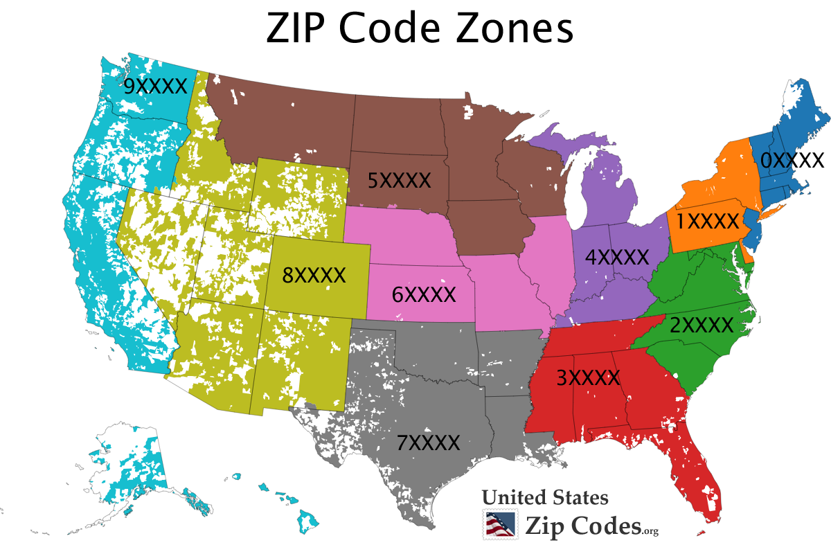
ZIP codes by state are essential for mail delivery, logistics, and geographic identification across the United States. Managed by the United States Postal Service, ZIP codes help organize regions efficiently, ensuring accurate and timely delivery of mail and packages.
Understanding ZIP codes by state allows businesses, developers, and individuals to classify locations, improve shipping accuracy, and analyze regional data. Each state has a defined ZIP code range, often reflecting geographic groupings and postal routes.
What Are ZIP Codes and How Do They Work?
ZIP codes, short for “Zone Improvement Plan” codes, were introduced by the United States Postal Service in 1963. They consist of five digits, with optional extended formats (ZIP+4) for more precise delivery.
The structure of a ZIP code:
- First digit: Represents a group of U.S. states
- Next two digits: Indicate a regional facility or city
- Last two digits: Identify a specific post office or delivery area
This system ensures efficient mail sorting and routing nationwide.
ZIP Codes by State Table
Below is a comprehensive table of ZIP codes by state, including minimum and maximum ranges:
| ID | State Name | ST | ZIP Min | ZIP Max |
|---|---|---|---|---|
| 6 | Alaska | AK | 99501 | 99950 |
| 5 | Alabama | AL | 35004 | 36925 |
| 69 | Arkansas | AR | 71601 | 72959 |
| 8 | Arkansas (Texarkana) | AR | 75502 | 75502 |
| 7 | Arizona | AZ | 85001 | 86556 |
| 9 | California | CA | 90001 | 96162 |
| 10 | Colorado | CO | 80001 | 81658 |
| 11 | Connecticut | CT | 06001 | 06389 |
| 73 | Connecticut | CT | 06401 | 06928 |
| 13 | Dist of Columbia | DC | 20001 | 20039 |
| 74 | Dist of Columbia | DC | 20042 | 20599 |
| 63 | Dist of Columbia | DC | 20799 | 20799 |
| 12 | Delaware | DE | 19701 | 19980 |
| 14 | Florida | FL | 32004 | 34997 |
| 15 | Georgia | GA | 30001 | 31999 |
| 65 | Georgia (Atlanta) | GA | 39901 | 39901 |
| 16 | Hawaii | HI | 96701 | 96898 |
| 20 | Iowa | IA | 50001 | 52809 |
| 66 | Iowa (Omaha) | IA | 68119 | 68120 |
| 17 | Idaho | ID | 83201 | 83876 |
| 18 | Illinois | IL | 60001 | 62999 |
| 19 | Indiana | IN | 46001 | 47997 |
| 21 | Kansas | KS | 66002 | 67954 |
| 22 | Kentucky | KY | 40003 | 42788 |
| 68 | Louisiana | LA | 70001 | 71232 |
| 23 | Louisiana | LA | 71234 | 71497 |
| 26 | Massachusetts | MA | 01001 | 02791 |
| 58 | Massachusetts (Andover) | MA | 05501 | 05544 |
| 77 | Maryland | MD | 20331 | 20331 |
| 78 | Maryland | MD | 20335 | 20797 |
| 25 | Maryland | MD | 20812 | 21930 |
| 24 | Maine | ME | 03901 | 04992 |
| 27 | Michigan | MI | 48001 | 49971 |
| 28 | Minnesota | MN | 55001 | 56763 |
| 57 | Missouri | MO | 63001 | 65899 |
| 29 | Mississippi | MS | 38601 | 39776 |
| 59 | Mississippi (Warren) | MS | 71233 | 71233 |
| 31 | Montana | MT | 59001 | 59937 |
| 38 | North Carolina | NC | 27006 | 28909 |
| 39 | North Dakota | ND | 58001 | 58856 |
| 67 | Nebraska | NE | 68001 | 68118 |
| 32 | Nebraska | NE | 68122 | 69367 |
| 34 | New Hampshire | NH | 03031 | 03897 |
| 35 | New Jersey | NJ | 07001 | 08989 |
| 36 | New Mexico | NM | 87001 | 88441 |
| 33 | Nevada | NV | 88901 | 89883 |
| 60 | New York (Fishers Island) | NY | 06390 | 06390 |
| 37 | New York | NY | 10001 | 14975 |
| 40 | Ohio | OH | 43001 | 45999 |
| 70 | Oklahoma | OK | 73001 | 73199 |
| 41 | Oklahoma | OK | 73401 | 74966 |
| 42 | Oregon | OR | 97001 | 97920 |
| 43 | Pennsylvania | PA | 15001 | 19640 |
| 44 | Puerto Rico | PR | 00000 | 00000 |
| 45 | Rhode Island | RI | 02801 | 02940 |
| 46 | South Carolina | SC | 29001 | 29948 |
| 47 | South Dakota | SD | 57001 | 57799 |
| 48 | Tennessee | TN | 37010 | 38589 |
| 49 | Texas (Austin) | TX | 73301 | 73301 |
| 71 | Texas | TX | 75001 | 75501 |
| 72 | Texas | TX | 75503 | 79999 |
| 61 | Texas (El Paso) | TX | 88510 | 88589 |
| 50 | Utah | UT | 84001 | 84784 |
| 64 | Virginia | VA | 20040 | 20041 |
| 75 | Virginia | VA | 20040 | 20167 |
| 76 | Virginia | VA | 20042 | 20042 |
| 52 | Virginia | VA | 22001 | 24658 |
| 51 | Vermont | VT | 05001 | 05495 |
| 62 | Vermont | VT | 05601 | 05907 |
| 53 | Washington | WA | 98001 | 99403 |
| 55 | Wisconsin | WI | 53001 | 54990 |
| 54 | West Virginia | WV | 24701 | 26886 |
| 56 | Wyoming | WY | 82001 | 83128 |
Key Insights About ZIP Codes by State
Geographic Distribution
ZIP codes by state generally follow a geographic pattern. Lower numbers start in the northeastern United States, while higher numbers extend westward.
For example:
- East Coast states like New York use ZIP codes starting with “1”
- Midwest states fall within the “4” to “6” range
- Western states like California and Washington use “9”
Special ZIP Code Areas
Some states have unique ZIP code allocations:
- Texas includes specific ZIP codes for cities like Austin and El Paso
- Georgia has a dedicated ZIP code for Atlanta (39901)
- New York includes a special ZIP code for Fishers Island
Overlapping and Multiple Ranges
Certain states have multiple ZIP code ranges due to population size and geographic spread. For instance:
- California covers a wide range from 90001 to 96162
- Texas has multiple ZIP segments across different regions
- Virginia includes several overlapping ZIP code blocks
Why ZIP Codes by State Matter
ZIP codes by state are crucial for:
- Shipping and logistics accuracy
- E-commerce operations
- Demographic and market analysis
- Emergency services and planning
- Government and census data organization
Businesses rely heavily on ZIP code data to optimize delivery routes, target customers, and improve operational efficiency.
How to Use ZIP Codes Effectively
To make the most of ZIP codes by state:
- Always verify ZIP codes using the United States Postal Service ZIP Code Locator
- Use ZIP+4 codes for precise delivery when available
- Segment customer data by ZIP codes for marketing campaigns
- Integrate ZIP code validation into online forms
Common Mistakes to Avoid
When working with ZIP codes:
- Avoid assuming all ZIP codes are continuous within a state
- Double-check special cases like standalone ZIP codes
- Do not ignore leading zeros in states like Massachusetts or New Jersey
- Ensure proper formatting in databases
Conclusion
ZIP codes by state provide a structured and efficient system for organizing mail delivery across the United States. From Alaska to Wyoming, each state has clearly defined ZIP code ranges that support logistics, commerce, and communication.
Understanding these ranges is essential for businesses, developers, and individuals who rely on accurate geographic data. By using ZIP codes correctly, you can improve efficiency, reduce errors, and gain valuable regional insights.