
After World War I, France acquired a mandate over the northern portion of the former Ottoman Empire province of Syria. The French administered the area until granting it independence in 1946. The new country lacked political stability and experienced a series of military coups. Syria united with Egypt in 1958 to form the United Arab Republic. In 1961, the two entities separated, and the Syrian Arab Republic was reestablished. In the 1967 Arab-Israeli War, Syria lost control of the Golan Heights region to Israel. During the 1990s, Syria and Israel held occasional, albeit unsuccessful, peace talks over its return. In 1970, Hafiz al-ASAD, a member of the socialist Ba’ath Party and the minority Alawi sect, seized power in a bloodless coup and brought political stability to the country. Following the death of al-ASAD, his son, Bashar al-ASAD, was approved as president by popular referendum in 2000. Syrian troops that were stationed in Lebanon since 1976 in an ostensible peacekeeping role were withdrawn in 2005. During the 2006 conflict between Israel and Hizballah, Syria placed its military forces on alert but did not intervene directly on behalf of its ally Hizballah. In 2007, Bashar al-ASAD’s second term as president was again approved in a referendum.
In the wake of major uprisings elsewhere in the region, antigovernment protests broke out in the southern province of Dar’a in 2011. Protesters called for the legalization of political parties, the removal of corrupt local officials, and the repeal of the restrictive Emergency Law allowing arrests without charge. Demonstrations and violent unrest spread across Syria, and the government responded with concessions, but also with military force and detentions that led to extended clashes and eventually civil war. International pressure on the Syrian Government intensified after 2011, as the Arab League, the EU, Turkey, and the US expanded economic sanctions against the ASAD regime and those entities that supported it. In 2012, more than 130 countries recognized the Syrian National Coalition as the sole legitimate representative of the Syrian people. In 2015, Russia launched a military intervention on behalf of the ASAD regime, and domestic and foreign-government-aligned forces recaptured swaths of territory from opposition forces. With foreign support, the regime continued to periodically regain opposition-held territory until 2020, when Turkish firepower halted a regime advance and forced a stalemate between regime and opposition forces. The government lacks territorial control over much of the northeastern part of the country, which the predominantly Kurdish Syrian Democratic Forces (SDF) hold, and a smaller area dominated by Turkey.
Since 2016, Turkey has conducted three large-scale military operations to capture territory along Syria’s northern border. Some opposition forces organized under the Turkish-backed Syrian National Army and Turkish forces have maintained control of northwestern Syria along the Turkish border with the Afrin area of Aleppo Province since 2018. The violent extremist organization Hay’at Tahrir al-Sham (formerly the Nusrah Front) emerged in 2017 as the predominant opposition force in Idlib Province, and still dominates an area also hosting Turkish forces. Negotiations have failed to produce a resolution to the conflict, and the UN estimated in 2022 that at least 306,000 people have died during the civil war. Approximately 6.7 million Syrians were internally displaced as of 2022, and 14.6 million people were in need of humanitarian assistance across the country. An additional 5.6 million Syrians were registered refugees in Turkey, Jordan, Iraq, Egypt, and North Africa. The conflict in Syria remains one of the two largest displacement crises worldwide (the other is the full-scale invasion of Ukraine).
On 8 December 2024, Syrian Islamist rebels captured the capital city of Damascus and overthrew President Bashar al-ASAD. The former president and his family fled to Moscow, where they were granted political asylum. The al-ASAD regime had ruled Syria for over 50 years.
Geography
Location
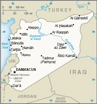
Middle East, bordering the Mediterranean Sea, between Lebanon and Turkey
Geographic coordinates
35 00 N, 38 00 E
Map references
Middle East
Area
total : 187,437 sq km
land: 185,887 sq km
water: 1,550 sq km
note: includes 1,295 sq km of Israeli-occupied territory
comparison ranking: total 89
Area – comparative
slightly more than 1.5 times the size of Pennsylvania
Area comparison map:

Land boundaries
total: 2,363 km
border countries (5): Iraq 599 km; Israel 83 km; Jordan 379 km; Lebanon 403 km; Turkey 899 km
Coastline
193 km
Maritime claims
territorial sea: 12 nm
contiguous zone: 24 nm
Climate
mostly desert; hot, dry, sunny summers (June to August) and mild, rainy winters (December to February) along coast; cold weather with snow or sleet periodically in Damascus
Terrain
primarily semiarid and desert plateau; narrow coastal plain; mountains in west
Elevation
highest point: Mount Hermon (Jabal a-Shayk) 2,814 m
lowest point: Yarmuk River -66 m
mean elevation: 514 m
Natural resources
petroleum, phosphates, chrome and manganese ores, asphalt, iron ore, rock salt, marble, gypsum, hydropower
Land use
agricultural land: 73.5% (2022 est.)
arable land: 23.8% (2022 est.)
permanent crops: 5.6% (2022 est.)
permanent pasture: 44.1% (2022 est.)
forest: 2.8% (2022 est.)
other: 23.7% (2022 est.)
Irrigated land
9,820 sq km (2022)
Major rivers (by length in km)
Euphrates (shared with Turkey [s], Iran, and Iraq [m]) – 3,596 km; Tigris (shared with Turkey, Iran, and Iraq [m]) – 1,950 km
note: [s] after country name indicates river source; [m] after country name indicates river mouth
Major watersheds (area sq km)
Indian Ocean drainage: (Persian Gulf) Tigris and Euphrates (918,044 sq km)
Population distribution
significant population density along the Mediterranean coast; larger concentrations found in the major cities of Damascus, Aleppo (the country’s largest city), and Hims (Homs); more than half of the population lives in the coastal plain, the province of Halab, and the Euphrates River valley
note: the recent civil war has altered the population distribution
Natural hazards
dust storms, sandstorms
volcanism: Syria’s two historically active volcanoes, Es Safa and an unnamed volcano near the Turkish border have not erupted in centuries
Geography – note
the capital of Damascus is located at an oasis fed by the Barada River and is thought to be one of the world’s oldest continuously inhabited cities; there are Israeli settlements and civilian land-use sites in the Israeli-controlled Golan Heights (2017)
People and Society
Population
total: 23,865,423 (2024 est.)
male: 11,981,578
female: 11,883,845
comparison rankings: total 57; female 58; male 57
Nationality
noun: Syrian(s)
adjective: Syrian
Ethnic groups
Arab ~50%, Alawite ~15%, Kurd ~10%, Levantine ~10%, other ~15% (includes Druze, Ismaili, Imami, Nusairi, Assyrian, Turkoman, Armenian)
Languages
Arabic (official), Kurdish, Armenian, Aramaic, Circassian, French, English
major-language sample(s):
كتاب حقائق العالم، المصدر الذي لا يمكن الاستغناء عنه للمعلومات الأساسية (Arabic)
ڕاستییەکانی جیهان، باشترین سەرچاوەیە بۆ زانیارییە بنەڕەتییەکان (Kurdish)
The World Factbook, the indispensable source for basic information.
Arabic audio sample:
Kurdish audio sample:
Religions
Muslim 87% (official; includes Sunni 74% and Alawi, Ismaili, and Shia 13%), Christian 10% (includes Orthodox, Uniate, and Nestorian), Druze 3%
note: the Christian population may be considerably smaller as a result of Christians fleeing the country during the ongoing civil war
Age structure
0-14 years: 33% (male 4,037,493/female 3,828,777)
15-64 years: 62.8% (male 7,475,355/female 7,522,797)
65 years and over: 4.2% (2024 est.) (male 468,730/female 532,271)
2024 population pyramid:

Dependency ratios
total dependency ratio: 59.1 (2024 est.)
youth dependency ratio: 52.4 (2024 est.)
elderly dependency ratio: 6.7 (2024 est.)
potential support ratio: 15 (2024 est.)
Median age
total: 24.1 years (2024 est.)
male: 23.6 years
female: 24.7 years
comparison ranking: total 178
Population growth rate
1.67% (2024 est.)
comparison ranking: 56
Birth rate
21.7 births/1,000 population (2024 est.)
comparison ranking: 57
Death rate
4 deaths/1,000 population (2024 est.)
comparison ranking: 214
Net migration rate
-1.1 migrant(s)/1,000 population (2024 est.)
comparison ranking: 147
Population distribution
significant population density along the Mediterranean coast; larger concentrations found in the major cities of Damascus, Aleppo (the country’s largest city), and Hims (Homs); more than half of the population lives in the coastal plain, the province of Halab, and the Euphrates River valley
note: the recent civil war has altered the population distribution
Urbanization
urban population: 57.4% of total population (2023)
rate of urbanization: 5.38% annual rate of change (2020-25 est.)
Major urban areas – population
2.585 million DAMASCUS (capital), 2.203 million Aleppo, 1.443 million Hims (Homs), 996,000 Hamah (2023)
Sex ratio
at birth: 1.06 male(s)/female
0-14 years: 1.05 male(s)/female
15-64 years: 0.99 male(s)/female
65 years and over: 0.88 male(s)/female
total population: 1.01 male(s)/female (2024 est.)
Maternal mortality ratio
30 deaths/100,000 live births (2020 est.)
comparison ranking: 111
Infant mortality rate
total: 15.1 deaths/1,000 live births (2024 est.)
male: 16.6 deaths/1,000 live births
female: 13.5 deaths/1,000 live births
comparison ranking: total 92
Life expectancy at birth
total population: 74.8 years (2024 est.)
male: 73.4 years
female: 76.4 years
comparison ranking: total population 137
Total fertility rate
2.69 children born/woman (2024 est.)
comparison ranking: 60
Gross reproduction rate
1.31 (2024 est.)
Contraceptive prevalence rate
NA
Drinking water source
improved:
urban: 99.6% of population
rural: 100% of population
total: 99.8% of population
unimproved:
urban: 0.4% of population
rural: 0.7% of population
total: 0.2% of population (2020 est.)
Health expenditure
7.8% of national budget (2022 est.)
Physician density
1.52 physicians/1,000 population (2021)
Hospital bed density
1.4 beds/1,000 population (2021 est.)
Sanitation facility access
improved:
urban: 99.5% of population
rural: 99.5% of population
total: 99.5% of population
unimproved:
urban: 0.5% of population
rural: 0.5% of population
total: 0.5% of population (2020 est.)
Obesity – adult prevalence rate
27.8% (2016)
comparison ranking: 35
Alcohol consumption per capita
total: 0.13 liters of pure alcohol (2019 est.)
beer: 0.02 liters of pure alcohol (2019 est.)
wine: 0 liters of pure alcohol (2019 est.)
spirits: 0.11 liters of pure alcohol (2019 est.)
other alcohols: 0 liters of pure alcohol (2019 est.)
comparison ranking: total 176
Currently married women (ages 15-49)
52.6% (2023 est.)
Literacy
total population: 94% (2021 est.)
male: 97% (2021 est.)
female: 92% (2021 est.)
School life expectancy (primary to tertiary education)
total: 9 years
male: 9 years
female: 9 years (2013)
Environment
Environment – current issues
deforestation; overgrazing; soil erosion; desertification; depletion of water resources; water pollution from raw sewage and petroleum refining wastes; inadequate potable water
Environment – international agreements
party to: Biodiversity, Climate Change, Climate Change-Kyoto Protocol, Climate Change-Paris Agreement, Desertification, Endangered Species, Hazardous Wastes, Marine Dumping-London Convention, Nuclear Test Ban, Ozone Layer Protection, Ship Pollution, Wetlands
signed, but not ratified: Environmental Modification
Climate
mostly desert; hot, dry, sunny summers (June to August) and mild, rainy winters (December to February) along coast; cold weather with snow or sleet periodically in Damascus
Land use
agricultural land: 73.5% (2022 est.)
arable land: 23.8% (2022 est.)
permanent crops: 5.6% (2022 est.)
permanent pasture: 44.1% (2022 est.)
forest: 2.8% (2022 est.)
other: 23.7% (2022 est.)
Urbanization
urban population: 57.4% of total population (2023)
rate of urbanization: 5.38% annual rate of change (2020-25 est.)
Air pollutants
particulate matter emissions: 25.14 micrograms per cubic meter (2019 est.)
carbon dioxide emissions: 28.83 megatons (2016 est.)
methane emissions: 12.93 megatons (2020 est.)
Waste and recycling
municipal solid waste generated annually: 4.5 million tons (2009 est.)
municipal solid waste recycled annually: 112,500 tons (2010 est.)
percent of municipal solid waste recycled: 2.5% (2010 est.)
Major rivers (by length in km)
Euphrates (shared with Turkey [s], Iran, and Iraq [m]) – 3,596 km; Tigris (shared with Turkey, Iran, and Iraq [m]) – 1,950 km
note: [s] after country name indicates river source; [m] after country name indicates river mouth
Major watersheds (area sq km)
Indian Ocean drainage: (Persian Gulf) Tigris and Euphrates (918,044 sq km)
Total water withdrawal
municipal: 1.48 billion cubic meters (2020 est.)
industrial: 620 million cubic meters (2020 est.)
agricultural: 14.67 billion cubic meters (2020 est.)
Total renewable water resources
16.8 billion cubic meters (2020 est.)
Government
Country name
conventional long form: Syrian Arab Republic
conventional short form: Syria
local long form: Al Jumhuriyah al Arabiyah as Suriyah
local short form: Suriyah
former: United Arab Republic (with Egypt)
etymology: the source of the name is uncertain; the name appears as “Suri” in Babylonian cuneiform writings dating from about 4000 B.C.
Government type
presidential republic; highly authoritarian regime
Capital
name: Damascus
geographic coordinates: 33 30 N, 36 18 E
time difference: UTC+3 (8 hours ahead of Washington, DC, during Standard Time)
etymology: the city has an ancient, pre-Semitic name of unknown origin
Administrative divisions
14 provinces (muhafazat, singular – muhafazah); Al Hasakah, Al Ladhiqiyah (Latakia), Al Qunaytirah, Ar Raqqah, As Suwayda’, Dar’a, Dayr az Zawr, Dimashq (Damascus), Halab (Aleppo), Hamah, Hims (Homs), Idlib, Rif Dimashq (Damascus Countryside), Tartus
Legal system
mixed system of civil and Islamic (sharia) law (for family courts)
Constitution
history: Syria’s 2012 constitution was rescinded by the Hayat Tahrir al-Sham-led government in January 2025; in March 2025, interim authorities announced a transitional constitution to remain in effect for up to five years
International law organization participation
has not submitted an ICJ jurisdiction declaration; non-party state to the ICC
Citizenship
citizenship by birth: no
citizenship by descent only: the father must be a citizen of Syria; if the father is unknown or stateless, the mother must be a citizen of Syria
dual citizenship recognized: yes
residency requirement for naturalization: 10 years
Suffrage
18 years of age; universal
Executive branch
chief of state: vacant; former President Bashar al-ASAD was overthrown by Islamist rebels on 8 December 2024; ASAD and his family flew to Moscow where they were granted political asylum
head of government: Prime Minister Muhammad al-BASHIR (since 8 December 2024)
cabinet: Council of Ministers appointed by the president
elections/appointments: president directly elected by simple majority popular vote for a 7-year term (eligible for a second term); election last held on 26 May 2021 (next to be held in 2028); the president appoints the vice president and prime minister
election results:
2021: Bashar al-ASAD elected president; percent of vote – Bashar al-ASAD (Ba’th Party) 95.2%, Mahmoud Ahmad MAREI (Democratic Arab Socialist Union) 3.3%, other 1.5%
2014: Bashar al-ASAD elected president; percent of vote – Bashar al-ASAD (Ba’th Party) 88.7%, Hassan al-NOURI (independent) 4.3%, Maher HAJJER (independent) 3.2%, other/invalid 3.8%
Legislative branch
legislature name: People’s Assembly (Majlis Al-Chaab)
legislative structure: unicameral
number of seats: 250 (all directly elected)
electoral system: plurality/majority
scope of elections: full renewal
term in office: 4 years
most recent election date: 7/15/2024
percentage of women in chamber: 9.6%
expected date of next election: July 2028
Judicial branch
highest court(s): Court of Cassation (organized into civil, criminal, religious, and military divisions, each with 3 judges); Supreme Constitutional Court (consists of 7 members)
judge selection and term of office: Court of Cassation judges appointed by the Supreme Judicial Council (SJC), a judicial management body headed by the minister of justice with 7 members, including the national president; judge tenure NA; Supreme Constitutional Court judges nominated by the president and appointed by the SJC; judges serve 4-year renewable terms
subordinate courts: courts of first instance; magistrates’ courts; religious and military courts; Economic Security Court; Counterterrorism Court
Political parties
legal parties/alliances:
Arab Socialist Ba’ath Party
Arab Socialist (Ba’ath) Party – Syrian Regional
Arab Socialist Ba’ath Party – Syrian Regional Branch, Socialist Unionist Democratic Party
Arab Socialist Union of Syria or ASU
Democratic Arab Socialist Union
National Progressive Front or NPF
Socialist Unionist Democratic Party
Socialist Unionist Party
Syrian Communist Party (two branches)
Syrian Social Nationalist Party or SSNP
Unionist Socialist Party
major political organizations:
Kurdish Democratic Union Party or PYD
Kurdish National Council or KNC
Syriac Union Party
Syrian Democratic Council or SDC
Syrian Democratic Party
Syrian Opposition Coalition
de facto governance entities:
Democratic Autonomous Administration of Northeast Syria or DAANES
Syrian Interim Government or SIG
Syrian Salvation Government or SSG
Diplomatic representation in the US
none
Note: operations at the embassy were suspended on 18 March 2014
Diplomatic representation from the US
chief of mission: Ambassador (vacant); note – on 6 February 2012, the US suspended operations at its embassy in Damascus; Czechia serves as a protecting power for US interests in Syria
mailing address: 6110 Damascus Place, Washington DC 20521-6110
email address and website:
[email protected]
https://sy.usembassy.gov/
International organization participation
ABEDA, AFESD, AMF, CAEU, FAO, G-24, G-77, IAEA, IBRD, ICAO, ICC (national committees), ICRM, ICSID, IDA, IDB, IFAD, IFC, IFRCS, IHO, ILO, IMF, IMO, Interpol, IOC, IPU, ISO, ITSO, ITU, LAS, MIGA, NAM, OAPEC, OIC, OPCW, UN, UNCTAD, UNESCO, UNIDO, UNRWA, UNWTO, UPU, WBG, WCO, WFTU (NGOs), WHO, WIPO, WMO, WTO (observer)
Independence
17 April 1946 (from League of Nations mandate under French administration)
National holiday
Independence Day (Evacuation Day), 17 April (1946); note – celebrates the leaving of the last French troops and the proclamation of full independence
Flag description
three equal horizontal bands of red (top), white, and black; two green five-pointed stars in a horizontal line centered in the white band; the band colors come from the Arab Liberation flag and represent oppression (black) overcome through bloody struggle (red), to be replaced by a bright future (white); identical to the former flag of the United Arab Republic (1958-1961), where the two stars represented the constituent states of Syria and Egypt; the current design dates to 1980
note: similar to the flags of Yemen (plain white band), Iraq (Arabic inscription centered in the white band), and Egypt (gold Eagle of Saladin centered in the white band)
National symbol(s)
northern bald ibis
National colors
red, white, black, green
National anthem
name: “Humat ad-Diyar” (Guardians of the Homeland)
lyrics/music: Khalil Mardam BEY/Mohammad Salim FLAYFEL and Ahmad Salim FLAYFEL
note: adopted 1936, restored 1961; between 1958 and 1961, while Syria was a member of the United Arab Republic with Egypt, the country had a different anthem
National heritage
total World Heritage Sites: 6 (all cultural)
selected World Heritage Site locales: Ancient City of Damascus; Ancient City of Bosra; Site of Palmyra; Ancient City of Aleppo; Crac des Chevaliers and Qal’at Salah El-Din; Ancient Villages of Northern Syria
Economy
Economic overview
low-income Middle Eastern economy; prior infrastructure and economy devastated by 11-year civil war; ongoing US sanctions; sporadic trans-migration during conflict; currently being supported by World Bank trust fund; ongoing hyperinflation
Real GDP (purchasing power parity)
$100.066 billion (2022 est.)
$99.338 billion (2021 est.)
$97.529 billion (2020 est.)
note: data in 2021 dollars
comparison ranking: 99
Real GDP growth rate
0.73% (2022 est.)
1.85% (2021 est.)
-0.18% (2020 est.)
note: annual GDP % growth based on constant local currency
comparison ranking: 173
Real GDP per capita
$4,500 (2022 est.)
$4,600 (2021 est.)
$4,600 (2020 est.)
note: data in 2021 dollars
comparison ranking: 182
GDP (official exchange rate)
$23.623 billion (2022 est.)
note: data in current dollars at official exchange rate
Inflation rate (consumer prices)
13.4% (2019 est.)
0.9% (2018 est.)
18.1% (2017 est.)
comparison ranking: 194
GDP – composition, by sector of origin
agriculture: 43.1% (2022 est.)
industry: 12% (2022 est.)
services: 44.9% (2022 est.)
note: figures may not total 100% due to non-allocated consumption not captured in sector-reported data
comparison rankings: services 176; industry 181; agriculture 2
GDP – composition, by end use
household consumption: 114.8% (2022 est.)
government consumption: 2.7% (2022 est.)
investment in fixed capital: 4.5% (2022 est.)
exports of goods and services: 6.8% (2022 est.)
imports of goods and services: -28.8% (2022 est.)
note: figures may not total 100% due to rounding or gaps in data collection
Agricultural products
wheat, barley, milk, sheep milk, tomatoes, olives, potatoes, maize, oranges, grapes (2023)
note: top ten agricultural products based on tonnage
Industries
petroleum, textiles, food processing, beverages, tobacco, phosphate rock mining, cement, oil seeds crushing, automobile assembly
Industrial production growth rate
-13.39% (2022 est.)
note: annual % change in industrial value added based on constant local currency
comparison ranking: 214
Labor force
6.617 million (2024 est.)
note: number of people ages 15 or older who are employed or seeking work
comparison ranking: 71
Unemployment rate
13% (2024 est.)
13.2% (2023 est.)
13.3% (2022 est.)
note: % of labor force seeking employment
comparison ranking: 177
Youth unemployment rate (ages 15-24)
total: 31.5% (2024 est.)
male: 27.8% (2024 est.)
female: 47.9% (2024 est.)
note: % of labor force ages 15-24 seeking employment
comparison ranking: total 22
Population below poverty line
82.5% (2014 est.)
Gini Index coefficient – distribution of family income
26.6 (2022 est.)
comparison ranking: 144
Household income or consumption by percentage share
lowest 10%: 3.8% (2022 est.)
highest 10%: 21.1% (2022 est.)
Remittances
0% of GDP (2022 est.)
0% of GDP (2021 est.)
0% of GDP (2020 est.)
note: personal transfers and compensation between resident and non-resident individuals/households/entities
Budget
revenues: $1.162 billion (2017 est.)
expenditures: $3.211 billion (2017 est.)
note: government projections for FY2016
Public debt
94.8% of GDP (2017 est.)
comparison ranking: 26
Taxes and other revenues
4.2% (of GDP) (2017 est.)
comparison ranking: 199
Current account balance
-$2.123 billion (2017 est.)
-$2.077 billion (2016 est.)
comparison ranking: 158
Exports
$1.609 billion (2022 est.)
$2.227 billion (2021 est.)
$1.649 billion (2020 est.)
note: GDP expenditure basis – exports of goods and services in current dollars
comparison ranking: 170
Exports – partners
Turkey 29%, Saudi Arabia 16%, Lebanon 10%, India 10%, UAE 5% (2023)
note: top five export partners based on percentage share of exports
Exports – commodities
olive oil, phosphates, spice seeds, cotton, tomatoes (2023)
note: top five export commodities based on value in dollars
Imports
$6.803 billion (2022 est.)
$6.56 billion (2021 est.)
$3.751 billion (2020 est.)
note: GDP expenditure basis – imports of goods and services in current dollars
comparison ranking: 142
Imports – partners
Turkey 49%, UAE 11%, China 8%, Egypt 7%, Lebanon 3% (2023)
note: top five import partners based on percentage share of imports
Imports – commodities
tobacco, plastics, wheat flours, plastic products, seed oils (2023)
note: top five import commodities based on value in dollars
Reserves of foreign exchange and gold
$407.3 million (2017 est.)
$504.6 million (2016 est.)
comparison ranking: 173
Debt – external
$4.573 billion (2023 est.)
note: present value of external debt in current US dollars
comparison ranking: 74
Exchange rates
Syrian pounds (SYP) per US dollar –
Exchange rates:
2,505.747 (2022 est.)
1,256 (2021 est.)
877.945 (2020 est.)
436.5 (2019 est.)
436.5 (2018 est.)
Energy
Electricity access
electrification – total population: 89% (2022 est.)
electrification – urban areas: 100%
electrification – rural areas: 75%
Electricity
installed generating capacity: 9.636 million kW (2023 est.)
consumption: 15.522 billion kWh (2023 est.)
exports: 358.723 million kWh (2023 est.)
transmission/distribution losses: 4.214 billion kWh (2023 est.)
comparison rankings: transmission/distribution losses 156; exports 83; consumption 86; installed generating capacity 67
Electricity generation sources
fossil fuels: 95.6% of total installed capacity (2023 est.)
solar: 0.5% of total installed capacity (2023 est.)
hydroelectricity: 3.8% of total installed capacity (2023 est.)
biomass and waste: 0.2% of total installed capacity (2023 est.)
Coal
consumption: 15,000 metric tons (2023 est.)
imports: 15,000 metric tons (2023 est.)
Petroleum
total petroleum production: 65,000 bbl/day (2023 est.)
refined petroleum consumption: 102,000 bbl/day (2023 est.)
crude oil estimated reserves: 2.5 billion barrels (2021 est.)
Natural gas
production: 2.763 billion cubic meters (2023 est.)
consumption: 2.763 billion cubic meters (2023 est.)
proven reserves: 240.693 billion cubic meters (2021 est.)
Carbon dioxide emissions
20.243 million metric tonnes of CO2 (2023 est.)
from coal and metallurgical coke: 33,000 metric tonnes of CO2 (2023 est.)
from petroleum and other liquids: 14.79 million metric tonnes of CO2 (2023 est.)
from consumed natural gas: 5.42 million metric tonnes of CO2 (2023 est.)
comparison ranking: total emissions 84
Energy consumption per capita
13.569 million Btu/person (2023 est.)
comparison ranking: 143
Communications
Telephones – fixed lines
total subscriptions: 2.816 million (2023 est.)
subscriptions per 100 inhabitants: 12 (2023 est.)
comparison ranking: total subscriptions 39
Telephones – mobile cellular
total subscriptions: 15.1 million (2023 est.)
subscriptions per 100 inhabitants: 80 (2021 est.)
comparison ranking: total subscriptions 71
Broadcast media
state-run TV has 2 networks and 5 satellite channels; roughly two-thirds of homes have a satellite dish with access to foreign TV; 3 state-run radio channels; first private radio station launched in 2005; private radio broadcasters prohibited from transmitting news or political content (2018)
Internet country code
.sy
Internet users
percent of population: 35% (2019 est.)
Broadband – fixed subscriptions
total: 1.62 million (2023 est.)
subscriptions per 100 inhabitants: 7 (2023 est.)
comparison ranking: total 68
Transportation
Civil aircraft registration country code prefix
YK
Airports
42 (2025)
comparison ranking: 99
Heliports
13 (2025)
comparison ranking: 63
Railways
total: 2,052 km (2014)
standard gauge: 1,801 km (2014) 1.435-m gauge
narrow gauge: 251 km (2014) 1.050-m gauge
Merchant marine
total: 24 (2023)
by type: bulk carrier 1, container ship 1, general cargo 8, oil tanker 1, other 13
comparison ranking: total 144
Ports
total ports: 3 (2024)
large: 1
medium: 1
small: 1
very small: 0
ports with oil terminals: 3
key ports: Al Ladhiqiyah, Baniyas, Tartus
Military and Security
Military and security forces
as of early 2025, the interim government authorities in Syria had established a ministry of defense and were seeking to unify the dozens of armed factions operating in Syria under a single, state-linked army and police force (2025)
Military expenditures
6.5% of GDP (2019 est.)
6.7% of GDP (2018 est.)
6.8% of GDP (2017 est.)
6.9% of GDP (2016 est.)
7.2% of GDP (2015 est.)
Military and security service personnel strengths
not available
Military equipment inventories and acquisitions
prior to the fall of the ASAD regime in December 2024, the SAF was inventory was comprised mostly of Russian and Soviet-era weapons and equipment (2024)
Military service age and obligation
prior to the fall of the ASAD regime in December 2024, men 18-42 were obligated to perform military service; compulsory service obligation was up to 30 months; women were not conscripted but could volunteer to serve, including in combat arms (2024)
Military – note
the UN Disengagement Observer Force (UNDOF) has operated in the Golan between Israel and Syria since 1974 to monitor the ceasefire following the 1973 Arab-Israeli War and supervise the areas of separation between the two countries; UNDOF has about 1,300 personnel (2025)
Space
Space agency/agencies
Syrian Space Agency (created in 2014); General Organization of Remote Sensing (GORS; established 1986 to replace the National Remote Sensing Center, established 1981) (2024)
Space program overview
status unclear; has been handicapped by the impact of the civil war, including the loss of students and scientists who fled the country; had previously focused on satellite development and related space technologies, as well as scientific research; has relations with the space agency and space industries of Russia (2024)
note: further details about the key activities, programs, and milestones of the country’s space program, as well as government spending estimates on the space sector, appear in the Space Programs reference guide
Terrorism
Terrorist group(s)
Terrorist group(s): Abdallah Azzam Brigades; Ansar al-Islam; Asa’ib Ahl Al-Haq; Hizballah; Hurras al-Din; Islamic Jihad Union; Islamic Revolutionary Guard Corps (IRGC)/Qods Force; Islamic State of Iraq and ash-Sham (ISIS); Kata’ib Hizballah; Kurdistan Workers’ Party (PKK); Hay’at Tahrir al-Sham (HTS; aka al-Nusrah Front ); al-Qa’ida; Palestine Liberation Front (PLF); Popular Front for the Liberation of Palestine (PFLP); PFLP-General Command (PLFP-GC)
note: details about the history, aims, leadership, organization, areas of operation, tactics, targets, weapons, size, and sources of support of the group(s) appear(s) in the Terrorism reference guide
Transnational Issues
Refugees and internally displaced persons
refugees (country of origin): 580,000 (Palestinian Refugees) (2022); 11,121 (Iraq) (2023)
IDPs: 6.865 million (ongoing civil war since 2011) (2022)
stateless persons: 160,000 (2022); note – Syria’s stateless population consists of Kurds and Palestinians; stateless persons are prevented from voting, owning land, holding certain jobs, receiving food subsidies or public healthcare, enrolling in public schools, or being legally married to Syrian citizens; in 1962, some 120,000 Syrian Kurds were stripped of their Syrian citizenship, rendering them and their descendants stateless; in 2011, the Syrian Government granted citizenship to thousands of Syrian Kurds as a means of appeasement; however, resolving the question of statelessness is not a priority given Syria’s ongoing civil war
note: the ongoing civil war has resulted in more than 5 million registered Syrian refugees – dispersed mainly in Egypt, Iraq, Jordan, Lebanon, and Turkey – as of March 2024
Trafficking in persons
tier rating: Tier 3 — Syria does not fully meet the minimum standards for the elimination of trafficking and is not making significant efforts to do so, therefore, Syria remained on Tier 3; for more details, go to: https://www.state.gov/reports/2024-trafficking-in-persons-report/syria/
Illicit drugs
increasing drug trafficking particularly the synthetic stimulant captagon, a mixture of various amphetamines, methamphetamine, and/or other stimulants; drug smuggling of captagon and other stimulants linked to the Syrian government and Hizballah


