
South Sudan, which gained independence from Sudan in 2011, is the world’s newest country. Home to a diverse array of mainly Nilotic ethnolinguistic groups that settled in the territory in the 15th through 19th centuries, South Sudanese society is heavily dependent on seasonal migration and seasonal fluctuations in precipitation. Modern-day South Sudan was conquered first by Egypt and later ruled jointly by Egyptian-British colonial administrators in the late 19th century. Christian missionaries helped spread the English language and Christianity in the area, leading to significant cultural differences with the northern part of Sudan, where Arabic and Islam are dominant. When Sudan gained its independence in 1956, the southern region received assurances that it would participate fully in the political system. However, the Arab government in Khartoum reneged on its promises, prompting two periods of civil war (1955-1972 and 1983-2005) in which as many as 2.5 million people died — mostly civilians — due largely to starvation and drought. The second Sudanese civil war was one of the deadliest since WWII and left southern Sudanese society devastated. Peace talks resulted in a US-backed Comprehensive Peace Agreement in 2005, which granted the South six years of autonomy followed by a referendum on final status. The result of this referendum, held in 2011, was a vote of 98% in favor of secession.
Since independence, South Sudan has struggled to form a viable governing system and has been plagued by widespread corruption, political conflict, and communal violence. In 2013, conflict erupted between forces loyal to President Salva KIIR, a Dinka, and forces loyal to Vice President Riek MACHAR, a Nuer. The conflict quickly spread through the country along ethnic lines, killing tens of thousands and creating a humanitarian crisis with millions of South Sudanese displaced. KIIR and MACHAR signed a peace agreement in 2015 that created a Transitional Government of National Unity the next year. However, renewed fighting broke out in Juba between KIIR and MACHAR’s forces, plunging the country back into conflict and drawing in additional armed opposition groups. A “revitalized” peace agreement was signed in 2018, mostly ending the fighting and laying the groundwork for a unified national army, a transitional government, and elections. The transitional government was formed in 2020, when MACHAR returned to Juba as first vice president. Since 2020, implementation of the peace agreement has been stalled amid wrangling over power-sharing, which has contributed to an uptick in communal violence and the country’s worst food crisis since independence, with 7 of 11 million South Sudanese citizens in need of humanitarian assistance. The transitional period was extended an additional two years in 2022, pushing elections to late 2024.
Geography
Location
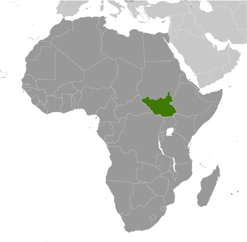
East-Central Africa; south of Sudan, north of Uganda and Kenya, west of Ethiopia
Geographic coordinates
8 00 N, 30 00 E
Map references
Africa
Area
total : 644,329 sq km
land: NA
water: NA
comparison ranking: total 44
Area – comparative
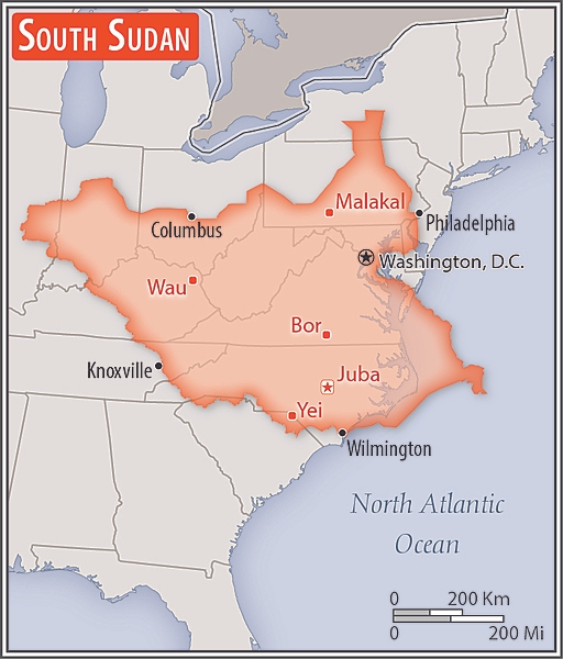
more than four times the size of Georgia; slightly smaller than Texas
Area comparison map:
Land boundaries
total: 6,018 km
border countries (6): Central African Republic 1,055 km; Democratic Republic of the Congo 714 km; Ethiopia 1,299 km; Kenya 317 km; Sudan 2,158 km; Uganda 475 km
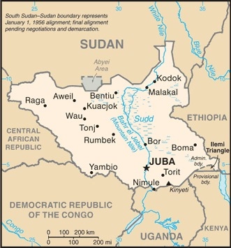
note: South Sudan-Sudan boundary represents 1 January 1956 alignment; final alignment pending negotiations and demarcation; final sovereignty status of Abyei Area pending negotiations between South Sudan and Sudan
Coastline
0 km (landlocked)
Maritime claims
none (landlocked)
Climate
hot with seasonal rainfall influenced by the annual shift of the Inter-Tropical Convergence Zone; rainfall heaviest in upland areas of the south and diminishes to the north
Terrain
plains in the north and center rise to southern highlands along the border with Uganda and Kenya; the White Nile, flowing north out of the uplands of Central Africa, is the major geographic feature of the country; The Sudd (a name derived from floating vegetation that hinders navigation) is a large swampy area of more than 100,000 sq km fed by the waters of the White Nile that dominates the center of the country
Elevation
highest point: Kinyeti 3,187 m
lowest point: White Nile 381 m
Natural resources
hydropower, fertile agricultural land, gold, diamonds, petroleum, hardwoods, limestone, iron ore, copper, chromium ore, zinc, tungsten, mica, silver
Land use
agricultural land: 44.7% (2022 est.)
arable land: 3.8% (2022 est.)
permanent crops: 0.1% (2022 est.)
permanent pasture: 40.8% (2022 est.)
forest: 11.3% (2022 est.)
other: 44% (2022 est.)
Irrigated land
1,000 sq km (2012)
Major rivers (by length in km)
Nile (shared with Rwanda [s], Tanzania, Uganda, Sudan, and Egypt [m]) – 6,650 km
note: [s] after country name indicates river source; [m] after country name indicates river mouth
Major watersheds (area sq km)
Atlantic Ocean drainage: Congo (3,730,881 sq km), (Mediterranean Sea) Nile (3,254,853 sq km)
Population distribution
clusters found in urban areas, particularly in the western interior and around the White Nile, as shown in this population distribution map
Geography – note
landlocked; The Sudd is a vast swamp in the north central region of South Sudan, formed by the White Nile; its size is variable but can reach some 15% of the country’s total area during the rainy season; it is one of the world’s largest wetlands
People and Society
Population
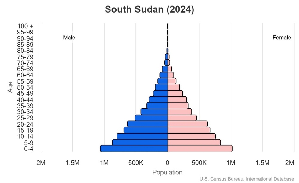
total: 12,703,714 (2024 est.)
male: 6,476,341
female: 6,227,373
comparison rankings: total 79; female 79; male 80
Nationality
noun: South Sudanese (singular and plural)
adjective: South Sudanese
Ethnic groups
Dinka (Jieng) approximately 35-40%, Nuer (Naath) approximately 15%, Shilluk (Chollo), Azande, Bari, Kakwa, Kuku, Murle, Mandari, Didinga, Ndogo, Bviri, Lndi, Anuak, Bongo, Lango, Dungotona, Acholi, Baka, Fertit (2011 est.)
note: Figures are estimations due to population changes during South Sudan’s civil war and the lack of updated demographic studies
Languages
English (official), Arabic (includes Juba and Sudanese variants), ethnic languages include Dinka, Nuer, Bari, Zande, Shilluk
major-language sample(s):
The World Factbook, the indispensable source for basic information. (English)
كتاب حقائق العالم، المصدر الذي لا يمكن الاستغناء عنه للمعلومات الأساسية (Arabic)
Arabic audio sample:
Religions
Christian 60.5%, folk religion 32.9%, Muslim 6.2%, other <1%, unaffiliated <1% (2020 est.)
Age structure
0-14 years: 42.1% (male 2,725,520/female 2,619,035)
15-64 years: 55.3% (male 3,568,064/female 3,458,804)
65 years and over: 2.6% (2024 est.) (male 182,757/female 149,534)
2024 population pyramid:
Dependency ratios
total dependency ratio: 80.8 (2024 est.)
youth dependency ratio: 76.1 (2024 est.)
elderly dependency ratio: 4.7 (2024 est.)
potential support ratio: 21.1 (2024 est.)
Median age
total: 18.7 years (2024 est.)
male: 18.7 years
female: 18.7 years
comparison ranking: total 217
Population growth rate
4.65% (2024 est.)
comparison ranking: 1
Birth rate
36.4 births/1,000 population (2024 est.)
comparison ranking: 10
Death rate
8.9 deaths/1,000 population (2024 est.)
comparison ranking: 65
Net migration rate
19.1 migrant(s)/1,000 population (2024 est.)
comparison ranking: 2
Population distribution
clusters found in urban areas, particularly in the western interior and around the White Nile, as shown in this population distribution map
Urbanization
urban population: 21.2% of total population (2023)
rate of urbanization: 4.12% annual rate of change (2020-25 est.)
Major urban areas – population
459,000 JUBA (capital) (2023)
Sex ratio
at birth: 1.05 male(s)/female
0-14 years: 1.04 male(s)/female
15-64 years: 1.03 male(s)/female
65 years and over: 1.22 male(s)/female
total population: 1.04 male(s)/female (2024 est.)
Maternal mortality ratio
1,223 deaths/100,000 live births (2020 est.)
comparison ranking: 1
Infant mortality rate
total: 60.1 deaths/1,000 live births (2024 est.)
male: 65.8 deaths/1,000 live births
female: 54.1 deaths/1,000 live births
comparison ranking: total 8
Life expectancy at birth
total population: 60.3 years (2024 est.)
male: 58.4 years
female: 62.2 years
comparison ranking: total population 220
Total fertility rate
5.09 children born/woman (2024 est.)
comparison ranking: 9
Gross reproduction rate
2.48 (2024 est.)
Contraceptive prevalence rate
NA
Drinking water source
improved:
urban: 88.7% of population
rural: 75.8% of population
total: 78.4% of population
unimproved:
urban: 11.3% of population
rural: 24.2% of population
total: 21.6% of population (2020 est.)
Health expenditure
5.9% of GDP (2021)
2.1% of national budget (2022 est.)
Physician density
0.04 physicians/1,000 population (2022)
Sanitation facility access
improved:
urban: 60.6% of population
rural: 15.5% of population
total: 24.6% of population
unimproved:
urban: 39.4% of population
rural: 84.5% of population
total: 75.4% of population (2020 est.)
Obesity – adult prevalence rate
6.6% (2014)
comparison ranking: 166
Currently married women (ages 15-49)
72% (2023 est.)
Education expenditure
1.6% of GDP (2016 est.)
8.1% national budget (2023 est.)
comparison ranking: Education expenditure (% GDP) 191
Literacy
total population: 34.5%
male: 40.3%
female: 28.9% (2018)
Environment
Environment – current issues
water pollution; inadequate supplies of potable water; wildlife conservation and loss of biodiversity; deforestation; soil erosion; desertification; drought
Environment – international agreements
party to: Biodiversity, Climate Change, Climate Change-Paris Agreement, Desertification, Ozone Layer Protection, Wetlands
signed, but not ratified: none of the selected agreements
Climate
hot with seasonal rainfall influenced by the annual shift of the Inter-Tropical Convergence Zone; rainfall heaviest in upland areas of the south and diminishes to the north
Land use
agricultural land: 44.7% (2022 est.)
arable land: 3.8% (2022 est.)
permanent crops: 0.1% (2022 est.)
permanent pasture: 40.8% (2022 est.)
forest: 11.3% (2022 est.)
other: 44% (2022 est.)
Urbanization
urban population: 21.2% of total population (2023)
rate of urbanization: 4.12% annual rate of change (2020-25 est.)
Air pollutants
particulate matter emissions: 20.18 micrograms per cubic meter (2019 est.)
carbon dioxide emissions: 1.73 megatons (2016 est.)
methane emissions: 7.61 megatons (2020 est.)
Waste and recycling
municipal solid waste generated annually: 2,680,681 tons (2013 est.)
Major rivers (by length in km)
Nile (shared with Rwanda [s], Tanzania, Uganda, Sudan, and Egypt [m]) – 6,650 km
note: [s] after country name indicates river source; [m] after country name indicates river mouth
Major watersheds (area sq km)
Atlantic Ocean drainage: Congo (3,730,881 sq km), (Mediterranean Sea) Nile (3,254,853 sq km)
Total water withdrawal
municipal: 190 million cubic meters (2020 est.)
industrial: 230 million cubic meters (2020 est.)
agricultural: 240 million cubic meters (2020 est.)
Total renewable water resources
49.5 billion cubic meters (2020 est.)
Government
Country name
conventional long form: Republic of South Sudan
conventional short form: South Sudan
etymology: self-descriptive name from the country’s geographic position within Sudan prior to independence; the name Sudan derives from the Arabic balad-as-sudan, meaning “Land of the Black [peoples]”
Government type
presidential republic
Capital
name: Juba
geographic coordinates: 04 51 N, 31 37 E
time difference: UTC+2 (8 hours ahead of Washington, DC, during Standard Time)
etymology: the name comes from the name of a small Bari village that was located near the present-day city
Administrative divisions
10 states; Central Equatoria, Eastern Equatoria, Jonglei, Lakes, Northern Bahr el Ghazal, Unity, Upper Nile, Warrap, Western Bahr el Ghazal, Western Equatoria
note: in 2015, 28 new states were created, and 4 additional states in 2017; after the 2020 peace agreement, the country was again reorganized into the 10 original states, plus 2 administrative areas, Pibor and Ruweng, and 1 special administrative status area, Abyei (which is disputed between South Sudan and Sudan)
Constitution
history: previous 2005 (pre-independence); latest signed 7 July 2011, effective 9 July 2011 (Transitional Constitution of the Republic of South Sudan, 2011)
amendment process: proposed by the National Legislature or by the president of the republic; passage requires submission of the proposal to the Legislature at least one month prior to consideration, approval by at least two-thirds majority vote in both houses of the Legislature, and assent of the president
Citizenship
citizenship by birth: no
citizenship by descent only: at least one parent must be a citizen of South Sudan
dual citizenship recognized: yes
residency requirement for naturalization: 10 years
Suffrage
18 years of age; universal
Executive branch
chief of state: President Salva KIIR Mayardit (since 9 July 2011)
head of government: President Salva KIIR Mayardit (since 9 July 2011)
cabinet: National Council of Ministers appointed by the president, approved by the Transitional National Legislative Assembly
elections/appointments: president directly elected by simple majority popular vote for a 4-year term (eligible for a second term); election last held on 11 to 15 April 2010 (next election was scheduled for 2015 but has been postponed multiple times, currently to be held in December 2026)
election results:
2010: Salva KIIR Mayardit elected leader of then-Southern Sudan; percent of vote – Salva KIIR Mayardit (SPLM) 93%, Lam AKOL (SPLM-DC) 7%
note: the president is both chief of state and head of government
Legislative branch
legislature name: Législature nationale (National Legislature)
legislative structure: bicameral
Legislative branch – lower chamber
chamber name: Transitional National Legislative Assembly (Al-Majlis Al-Tachirii)
number of seats: 550 (all appointed)
scope of elections: full renewal
most recent election date: 5/10/2021
percentage of women in chamber: 32.4%
expected date of next election: December 2026
Legislative branch – upper chamber
chamber name: Council of States (Al-Watani)
number of seats: 100 (all appointed)
scope of elections: full renewal
most recent election date: 8/2/2021
percentage of women in chamber: 32.1%
expected date of next election: December 2026
Judicial branch
highest court(s): Supreme Court of South Sudan (consists of a chief justice, deputy chief justice, and 5 additional justices); the 2011 Transitional Constitution of South Sudan calls for 9, rather than 5 additional justices
judge selection and term of office: the 2011 Transitional Constitution of South Sudan calls for the establishment of a Judicial Service Council to recommend prospective justices to the president, and for the justices’ tenures to be set by the National Legislature
subordinate courts: national level – Courts of Appeal; High Courts; County Courts; state level – High Courts; County Courts; customary courts; other specialized courts and tribunals
note: in mid-2022, the Government of South Sudan inaugurated an ad-hoc judiciary committee, a 12-member body led by two eminent jurists, that is charged with reviewing relevant laws, advising on judicial reform, and restructuring the judiciary
Political parties
Democratic Change or DC
Democratic Forum or DF
Labour Party or LPSS
South Sudan Opposition Alliance or SSOA
Sudan African National Union or SANU
Sudan People’s Liberation Movement or SPLM
Sudan People’s Liberation Movement-In Opposition or SPLM-IO
United Democratic Salvation Front or UDSF
United South Sudan African Party or USSAP
United South Sudan Party or USSP
Diplomatic representation in the US
chief of mission: Ambassador Santino Fardol Watod DICKEN (since 18 September 2024)
chancery: 1015 31st Street NW, Suite 300, Washington, DC 20007
telephone: [1] (202) 600-2238
FAX: [1] (202) 644-9910
email address and website:
[email protected]
https://www.ssembassydc.org/
Diplomatic representation from the US
chief of mission: Ambassador Michael J. ADLER (since 24 August 2022)
embassy: Kololo Road adjacent to the EU’s compound, Juba
mailing address: 4420 Juba Place, Washington DC 20521-4420
telephone: [211] 912-105-188
email address and website:
[email protected]
https://ss.usembassy.gov/
International organization participation
AU, EAC, FAO, G-77, IBRD, ICAO, IDA, IFAD, IFC, IFRCS, IGAD, ILO, IMF, Interpol, IOM, IPU, ITU, MIGA, UN, UNCTAD, UNESCO, UPU, WCO, WHO, WMO
Independence
9 July 2011 (from Sudan)
National holiday
Independence Day, 9 July (2011)
Flag description
three equal horizontal bands of black (top), red, and green; the red band is edged in white; a blue isosceles triangle based on the hoist side has a gold, five-pointed star; black stands for the people, red for the blood shed in the struggle for freedom, green for the land, and blue for the Nile; the gold star represents the unity of the country’s states
note: resembles the flag of Kenya; South Sudan has one of two national flags that display six colors as part of the primary design — the other is South Africa’s
National symbol(s)
African fish eagle
National colors
red, green, blue, yellow, black, white
National anthem
name: “South Sudan Oyee!” (Hooray!)
lyrics/music: collective of 49 poets/Juba University students and teachers
note: adopted 2011; anthem selected in a national contest
Economy
Economic overview
low-income, oil-based Sahelian economy; extreme poverty and food insecurity; COVID-19 and ongoing violence threaten socioeconomic potential; environmentally fragile; ongoing land and property rights issues; natural resource rich but lacks infrastructure
Real GDP (purchasing power parity)
$20.01 billion (2017 est.)
$21.1 billion (2016 est.)
$24.52 billion (2015 est.)
note: data are in 2017 dollars
comparison ranking: 158
Real GDP growth rate
-5.2% (2017 est.)
-13.9% (2016 est.)
-10.79% (2015 est.)
note: annual GDP % growth based on constant local currency
comparison ranking: 214
Real GDP per capita
$1,600 (2017 est.)
$1,700 (2016 est.)
$2,100 (2015 est.)
note: data are in 2017 dollars
comparison ranking: 214
GDP (official exchange rate)
$11.998 billion (2015 est.)
note: data in current dollars at official exchange rate
Inflation rate (consumer prices)
2.4% (2023 est.)
-6.7% (2022 est.)
10.5% (2021 est.)
note: annual % change based on consumer prices
comparison ranking: 74
GDP – composition, by sector of origin
agriculture: 10.4% (2015 est.)
industry: 33.1% (2015 est.)
services: 56.6% (2015 est.)
note: figures may not total 100% due to non-allocated consumption not captured in sector-reported data
comparison rankings: services 115; industry 46; agriculture 75
GDP – composition, by end use
investment in fixed capital: 5.8% (2015 est.)
investment in inventories: 0% (2015 est.)
exports of goods and services: 36.7% (2015 est.)
imports of goods and services: -28.9% (2015 est.)
note: figures may not total 100% due to rounding or gaps in data collection
Agricultural products
milk, cassava, sorghum, goat milk, vegetables, fruits, groundnuts, sesame seeds, beef, maize (2023)
note: top ten agricultural products based on tonnage
Industrial production growth rate
-36.78% (2015 est.)
note: annual % change in industrial value added based on constant local currency
comparison ranking: 219
Labor force
5.091 million (2023 est.)
note: number of people ages 15 or older who are employed or seeking work
comparison ranking: 86
Unemployment rate
12.5% (2023 est.)
12.5% (2022 est.)
14% (2021 est.)
note: % of labor force seeking employment
comparison ranking: 176
Youth unemployment rate (ages 15-24)
total: 18.5% (2023 est.)
male: 19.4% (2023 est.)
female: 17.6% (2023 est.)
note: % of labor force ages 15-24 seeking employment
comparison ranking: total 67
Population below poverty line
82.3% (2016 est.)
note: % of population with income below national poverty line
Gini Index coefficient – distribution of family income
44.1 (2016 est.)
note: index (0-100) of income distribution; higher values represent greater inequality
comparison ranking: 25
Household income or consumption by percentage share
lowest 10%: 1.8% (2016 est.)
highest 10%: 33% (2016 est.)
Remittances
9.49% of GDP (2015 est.)
0.01% of GDP (2014 est.)
note: personal transfers and compensation between resident and non-resident individuals/households/entities
Budget
revenues: $1.94 billion (2019 est.)
expenditures: $1.938 billion (2019 est.)
Public debt
62.7% of GDP (2017 est.)
comparison ranking: 75
Taxes and other revenues
8.5% (of GDP) (FY2017/18 est.)
comparison ranking: 186
Current account balance
$577.9 million (2023 est.)
-$596.748 million (2022 est.)
-$6.55 million (2021 est.)
note: balance of payments – net trade and primary/secondary income in current dollars
comparison ranking: 64
Exports
$4.499 billion (2023 est.)
$5.811 billion (2022 est.)
$4.652 billion (2021 est.)
note: balance of payments – exports of goods and services in current dollars
comparison ranking: 144
Exports – partners
China 51%, Singapore 29%, UAE 10%, Germany 4%, Uganda 3% (2023)
note: top five export partners based on percentage share of exports
Exports – commodities
crude petroleum, refined petroleum, forage crops, gold, scrap iron (2023)
note: top five export commodities based on value in dollars
Imports
$4.443 billion (2023 est.)
$6.402 billion (2022 est.)
$4.037 billion (2021 est.)
note: balance of payments – imports of goods and services in current dollars
comparison ranking: 156
Imports – partners
Uganda 33%, UAE 26%, Kenya 14%, China 10%, USA 3% (2023)
note: top five import partners based on percentage share of imports
Imports – commodities
garments, cement, other foods, iron bars, cereal flours (2023)
note: top five import commodities based on value in dollars
Reserves of foreign exchange and gold
$72.881 million (2023 est.)
$94.914 million (2022 est.)
$341.932 million (2021 est.)
note: holdings of gold (year-end prices)/foreign exchange/special drawing rights in current dollars
comparison ranking: 191
Exchange rates
South Sudanese pounds (SSP) per US dollar –
Exchange rates:
930.331 (2023 est.)
534.511 (2022 est.)
306.355 (2021 est.)
165.907 (2020 est.)
157.999 (2019 est.)
Energy
Electricity access
electrification – total population: 8.4% (2022 est.)
electrification – urban areas: 15%
electrification – rural areas: 1.7%
Electricity
installed generating capacity: 136,000 kW (2023 est.)
consumption: 566.034 million kWh (2023 est.)
transmission/distribution losses: 23.966 million kWh (2023 est.)
comparison rankings: transmission/distribution losses 27; consumption 174; installed generating capacity 184
Electricity generation sources
fossil fuels: 93.2% of total installed capacity (2023 est.)
solar: 6.8% of total installed capacity (2023 est.)
Coal
imports: 100 metric tons (2022 est.)
Petroleum
total petroleum production: 146,000 bbl/day (2023 est.)
refined petroleum consumption: 11,000 bbl/day (2023 est.)
crude oil estimated reserves: 3.75 billion barrels (2021 est.)
Carbon dioxide emissions
1.725 million metric tonnes of CO2 (2023 est.)
from petroleum and other liquids: 1.725 million metric tonnes of CO2 (2023 est.)
comparison ranking: total emissions 162
Energy consumption per capita
2.092 million Btu/person (2023 est.)
comparison ranking: 185
Communications
Telephones – fixed lines
total subscriptions: 0 (2023 est.)
subscriptions per 100 inhabitants: (2023 est.) less than 1
comparison ranking: total subscriptions 225
Telephones – mobile cellular
total subscriptions: 6.17 million (2023 est.)
subscriptions per 100 inhabitants: 30 (2022 est.)
comparison ranking: total subscriptions 118
Broadcast media
1 state-controlled TV channel and radio station; several community and commercial FM stations, mostly sponsored by outside aid donors; some foreign radio broadcasts available (2019)
Internet country code
.ss
Internet users
percent of population: 9% (2022 est.)
Broadband – fixed subscriptions
total: 0 (2023 est.)
subscriptions per 100 inhabitants: (2023 est.) less than 1
comparison ranking: total 215
Transportation
Civil aircraft registration country code prefix
Z8
Airports
89 (2025)
comparison ranking: 62
Heliports
2 (2025)
comparison ranking: 129
Railways
total: 248 km (2018)
note: a narrow gauge, single-track railroad between Babonosa (Sudan) and Wau, the only existing rail system, was repaired in 2010 with $250 million in UN funds, but is not currently operational
Military and Security
Military and security forces
South Sudan People’s Defense Force (SSPDF): Land Forces (includes Presidential Guard), Air Forces, Marine (Riverine) Forces, Reserve Forces; National (or Necessary) Unified Forces (NUF)
Ministry of Interior: South Sudan National Police Service (SSNPS) (2025)
note 1: the NUF are being formed by retraining rebel and pro-government militia fighters into military, police, and other government security forces; the first operational NUF deployed in November 2023
note 2: numerous irregular forces operate in the country with official knowledge, including militias operated by the National Security Service (an internal security force under the Ministry of National Security) and proxy forces
Military expenditures
2% of GDP (2024 est.)
2% of GDP (2023 est.)
2% of GDP (2022 est.)
2% of GDP (2021 est.)
2% of GDP (2020 est.)
Military and security service personnel strengths
information varies; estimated 150-200,000 active Defense Forces (2025)
note: some active SSPDF personnel may be militia; the National/Necessary Unified Forces (NUF) were expected to have up to 80,000 personnel when training and integration is completed; the first batch of approximately 20,000 NUF personnel completed training in late 2022
Military equipment inventories and acquisitions
the SSPDF inventory is comprised primarily of Soviet-era equipment; South Sudan has been under a UN arms embargo since 2018 (2024)
Military service age and obligation
18 is the legal minimum age for compulsory (men) and voluntary (men and women) military service; 12-24 months service (2023)
Military – note
the South Sudan People’s Defense Forces (SSPDF) are largely focused on border and internal security; armed rebel groups and militias continue to operate in the country since the peace deal and formation of a unity government in 2018, including the National Salvation Front (NAS), the Sudan People’s Liberation Movement-in-Opposition (SPLA/IO), and the White Army militia
the SSPDF, formerly the Sudan People’s Liberation Army (SPLA), was founded as a guerrilla movement against the Sudanese Government in 1983 and participated in the Second Sudanese Civil War (1983-2005); the Juba Declaration that followed the Comprehensive Peace Agreement of 2005 unified the SPLA and the South Sudan Defense Forces (SSDF), the second-largest rebel militia remaining from the civil war, under the SPLA name; in 2017, the SPLA was renamed the South Sudan Defense Forces (SSDF) and in September 2018 was renamed again as the SSPDF
the UN Mission in South Sudan (UNMISS) has operated in the country since 2011 with the objectives of consolidating peace and security and helping establish conditions for the successful economic and political development of South Sudan; UNMISS has about 18,000 personnel deployed in the country; the UN Interim Security Force for Abyei (UNISFA) has operated in the disputed Abyei region along the border between Sudan and South Sudan since 2011; UNISFA’s mission includes ensuring security, protecting civilians, strengthening the capacity of the Abyei Police Service, de-mining, monitoring/verifying the redeployment of armed forces from the area, and facilitating the flow of humanitarian aid; UNISFA has approximately 3,800 personnel assigned (2025)
Transnational Issues
Refugees and internally displaced persons
refugees (country of origin): 564,738 (Sudan) (refugees since 15 April 2023), 13,833 (Democratic Republic of the Congo) (2024)
IDPs: 2.258 million (alleged coup attempt and ethnic conflict beginning in December 2013; information is lacking on those displaced in earlier years by: fighting in Abyei between the Sudanese Armed Forces and the Sudan People’s Liberation Army (SPLA) in May 2011; clashes between the SPLA and dissident militia groups in South Sudan; inter-ethnic conflicts over resources and cattle; attacks from the Lord’s Resistance Army; floods and drought) (2023)
stateless persons: 10,000 (2022)
Trafficking in persons
tier rating: Tier 3 — South Sudan does not fully meet the minimum standards for the elimination of trafficking and is not making significant efforts to do so, therefore, South Sudan remains on Tier 3; for more details, go to: https://www.state.gov/reports/2024-trafficking-in-persons-report/south-sudan/


