
The Arctic Ocean is the smallest of the world’s five ocean basins (after the Pacific Ocean, Atlantic Ocean, Indian Ocean, and the Southern Ocean). The Northwest Passage (US and Canada) and Northern Sea Route (Norway and Russia) are two important seasonal waterways. In recent years, the polar ice pack has receded in the summer allowing for increased navigation and raising the possibility of future sovereignty and shipping disputes among the Arctic coastal states affected (Canada, Denmark (Greenland), Iceland, Norway, Russia, US).
Geography
Location
body of water between Europe, Asia, and North America, mostly north of the Arctic Circle
Geographic coordinates
90 00 N, 0 00 E
Map references
Arctic Region
Area
total : 15.558 million sq km
note: includes Barents Sea, Beaufort Sea, Chukchi Sea, East Siberian Sea, Greenland Sea, Kara Sea, Laptev Sea, Northwest Passage, Norwegian Sea, and other tributary water bodies
Area – comparative
slightly less than 1.5 times the size of the US
Coastline
45,389 km
Climate
polar climate characterized by persistent cold and relatively narrow annual temperature range; winters characterized by continuous darkness, cold and stable weather conditions, and clear skies; summers characterized by continuous daylight, damp and foggy weather, and weak cyclones with rain or snow
Ocean volume
ocean volume: 18.75 million cu km
percent of World Ocean total volume: 1.4%
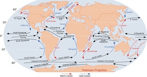
Major ocean currents
two major, slow-moving, wind-driven currents (drift streams) dominate: a clockwise drift pattern in the Beaufort Gyre in the western part of the Arctic Ocean and a nearly straight line Transpolar Drift Stream that moves eastward across the ocean from the New Siberian Islands (Russia) to the Fram Strait (between Greenland and Svalbard); sea ice that lies close to the center of the gyre can complete a 360 degree circle in about 2 years, while ice on the gyre periphery will complete the same circle in about 7-8 years; sea ice in the Transpolar Drift crosses the ocean in about 3 years
Major World Ocean Currents:
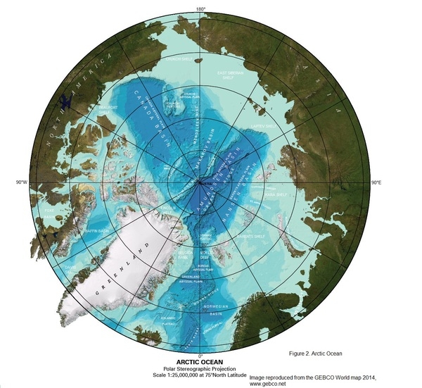
Bathymetry
continental shelf: more than one quarter of the Arctic sea floor; the Eurasian shelf is very wide, extending out 1,500 km (930 mi), and is the largest continental shelf in the world
the following are examples of continental-shelf features in the Arctic Ocean (see Figure 2):
Barents Shelf
Beaufort Shelf
Davis Sill
Chukchi Shelf
East Siberian Shelf
Kara Shelf
Laptev Shelf
Lincoln Shelf
continental slope: the following are examples of continental-slope features found in the Arctic Ocean (see Figure 2):
Litke Trough
Novaya Zemlya Trough
Svyataya Anna Trough (Saint Anna Trough)
Voronin Trough
abyssal plains: the following are examples of abyssal-plain features found in the Arctic Ocean (see Figure 2):
Baffin Basin
Canada Basin
Fram/Amundsen Basin
Greenland Abyssal Plain
Iceland Basin
Makarov Basin
Molloy Deep (deepest point in the Arctic Ocean)
Nansen Basin
Norwegian Basin
mid-ocean ridge: the following are examples of mid-ocean ridges found in the Arctic Ocean (see Figure 2):
Gakkel Ridge
Mohns Ridge
undersea terrain features:
the following are examples of undersea terrain features found on the floor of the Arctic Ocean (see Figure 2):
Lomonosov Ridge
Gakkel Ridge
Alpha Ridge
Mendeleev Rise
Chukchi Plateau
ocean trenches: there are no ocean trenches on the Arctic sea floor
atolls: there are no atolls found in the Arctic Ocean
Figure 1. Profile of the sea floor:
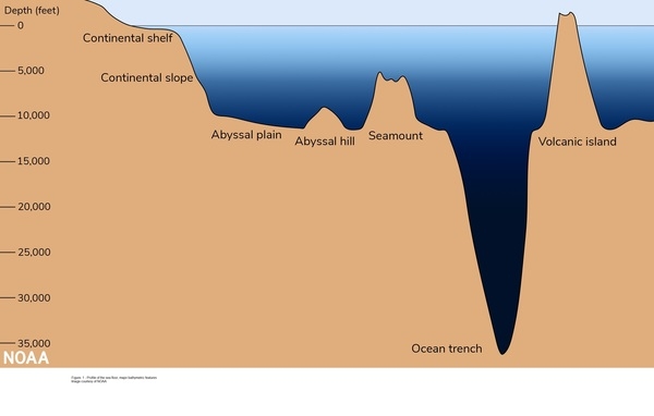
Figure 2. Arctic Ocean sea floor:
Elevation
highest point: sea level
lowest point: Molloy Deep -5,577 m
mean depth: -1,205 m
ocean zones: Composed of water and in a fluid state, the ocean is delimited differently than the solid continents. It is divided into three zones based on depth and light level. Sunlight entering the water may travel about 1,000 m into the oceans under the right conditions, but there is rarely any significant light beyond 200 m.
The upper 200 m (656 ft) of the ocean is called the euphotic, or “sunlight,” zone. This zone contains the vast majority of commercial fisheries and is home to many protected marine mammals and sea turtles. Only a small amount of light penetrates beyond this depth.
The zone between 200 m (656 ft) and 1,000 m (3,280 ft) is usually referred to as the “twilight” zone, but is officially the dysphotic zone. In this zone, the intensity of light rapidly dissipates as depth increases. Such a minuscule amount of light penetrates beyond a depth of 200 m that photosynthesis is no longer possible.
The aphotic, or “midnight,” zone exists in depths below 1,000 m (3,280 ft). Sunlight does not penetrate to these depths, and the zone is bathed in darkness.
Distance Sunlight Travels in the Ocean:

Natural resources
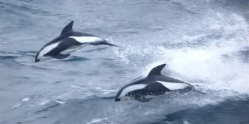
sand and gravel aggregates, placer deposits, polymetallic nodules, oil and gas fields, fish, marine mammals (seals and whales)
Natural hazards
ice islands occasionally break away from northern Ellesmere Island; icebergs calved from glaciers in western Greenland and extreme northeastern Canada; permafrost in islands; virtually ice locked from October to June; ships subject to superstructure icing from October to May
Geography – note
major chokepoint is the southern Chukchi Sea (northern access to the Pacific Ocean via the Bering Strait); strategic location between North America and Russia; shortest marine link between the extremes of eastern and western Russia; floating research stations operated by the US and Russia; maximum snow cover in March or April about 20 to 50 centimeters over the frozen ocean; snow cover lasts about 10 months
Environment
Environment – current issues
changes in biodiversity and temperature; water pollution from use of toxic chemicals; endangered marine species; ecosystem slow to recover from disruptions or damage; thinning polar icepack
Climate
polar climate characterized by persistent cold and relatively narrow annual temperature range; winters characterized by continuous darkness, cold and stable weather conditions, and clear skies; summers characterized by continuous daylight, damp and foggy weather, and weak cyclones with rain or snow
Marine fisheries
the Arctic fishery region (Region 18) is the smallest in the world with a catch of only 708 mt in 2019, although the Food and Agriculture Organization assesses that some Arctic catches are reported in adjacent regions; Russia and Canada were historically the major producers; in 2017, Canada, Denmark (Greenland), Iceland, Norway, Russia, and the US, along with the People’s Republic of China, the European Union, Japan, and the Republic of Korea, agreed to a 16-year ban on fishing in the Central Arctic Ocean to allow for time to study the ecological system of these waters
Regional fisheries bodies: International Council for the Exploration of the Seas; Agreement to Prevent Unregulated High Seas Fisheries in the Central Arctic OceanFAO map of world fishing regions, used with permission.
Government
Country name
etymology: the name comes from the Greek word arktikos meaning “near the bear” or “northern,” and that word derives from arktos, meaning “bear”; the name refers either to the constellation Ursa Major, the “Great Bear,” which is prominent in the northern celestial sphere, or to the constellation Ursa Minor, the “Little Bear,” which contains Polaris, the North (Pole) Star
Transportation
Transportation – note
sparse network of air, ocean, river, and land routes; the Northwest Passage (North America) and Northern Sea Route (Eurasia) are important seasonal waterways
Transnational Issues
Disputes – international
note: record levels of summer melting of sea ice in the Arctic has renewed interest in maritime shipping lanes and sea floor exploration


