
The Earth’s land surface covers a total area of approximately 143,804,549 square kilometers, encompassing continents, islands, and various landforms. This article presents a comprehensive analysis of the visual representation of land surface area, as depicted in the image, which ranks countries, territories, and regions based on their respective landmass.
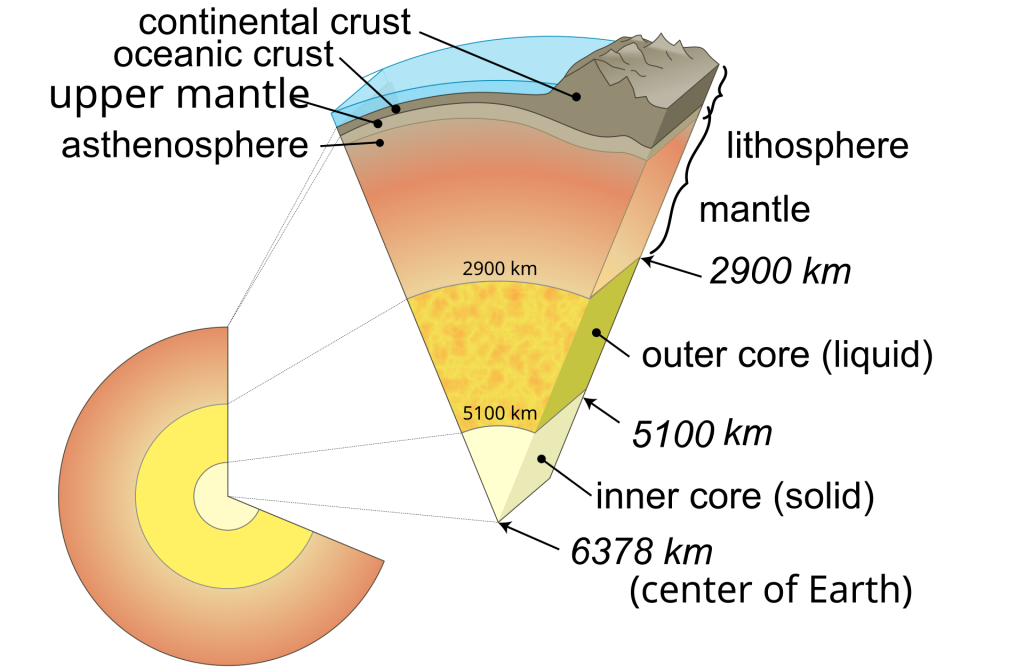
Earth is the third planet from the Sun and the only astronomical object known to harbor life. This is made possible by Earth being an ocean world, the only one in the Solar System sustaining liquid surface water. Almost all of Earth’s water is contained in its global ocean, covering 70.8% of Earth’s crust. The remaining 29.2% of Earth’s crust is land, most of which is located in the form of continental landmasses within Earth’s land hemisphere. Most of Earth’s land is at least somewhat humid and covered by vegetation, while large ice sheets at Earth’s polar deserts retain more water than Earth’s groundwater, lakes, rivers, and atmospheric water combined. Earth’s crust consists of slowly moving tectonic plates, which interact to produce mountain ranges, volcanoes, and earthquakes. Earth has a liquid outer core that generates a magnetosphere capable of deflecting most of the destructive solar winds and cosmic radiation.

Earth has a dynamic atmosphere, which sustains Earth’s surface conditions and protects it from most meteoroids and UV-light at entry. It is composed primarily of nitrogen and oxygen. Water vapor is widely present in the atmosphere, forming clouds that cover most of the planet. The water vapor acts as a greenhouse gas and, together with other greenhouse gases in the atmosphere, particularly carbon dioxide (CO2), creates the conditions for both liquid surface water and water vapor to persist via the capturing of energy from the Sun’s light. This process maintains the current average surface temperature of 14.76 °C (58.57 °F), at which water is liquid under normal atmospheric pressure. Differences in the amount of captured energy between geographic regions (as with the equatorial region receiving more sunlight than the polar regions) drive atmospheric and ocean currents, producing a global climate system with different climate regions, and a range of weather phenomena such as precipitation, allowing components such as carbon and nitrogen to cycle.

Earth is rounded into an ellipsoid with a circumference of about 40,000 kilometers (24,900 miles). It is the densest planet in the Solar System. Of the four rocky planets, it is the largest and most massive. Earth is about eight light-minutes (1 AU) away from the Sun and orbits it, taking a year (about 365.25 days) to complete one revolution. Earth rotates around its own axis in slightly less than a day (in about 23 hours and 56 minutes). Earth’s axis of rotation is tilted with respect to the perpendicular to its orbital plane around the Sun, producing seasons. Earth is orbited by one permanent natural satellite, the Moon, which orbits Earth at 384,400 km (238,855 mi)—1.28 light seconds—and is roughly a quarter as wide as Earth. The Moon’s gravity helps stabilize Earth’s axis, causes tides and gradually slows Earth’s rotation. Likewise, Earth’s gravitational pull has already made the Moon’s rotation tidally locked, keeping the same near side facing Earth.
Earth, like most other bodies in the Solar System, formed about 4.5 billion years ago from gas and dust in the early Solar System. The formation of the ocean and the subsequent development of life occurred during the first billion years of Earth’s history. Life spread globally and has been altering Earth’s atmosphere and surface, leading to the Great Oxidation Event two billion years ago. Humans emerged 300,000 years ago in Africa and have spread across every continent on Earth. Humans depend on Earth’s biosphere and natural resources for their survival, but have increasingly impacted the planet’s environment. Humanity’s current impact on Earth’s climate and biosphere is unsustainable, threatening the livelihood of humans and many other forms of life, and causing widespread extinctions.
The visual comparison provides valuable insight into the geographic scale of different nations, highlighting the largest and smallest landmasses. The image also emphasizes the relationship between land area, population distribution, and natural resources. This analysis aims to explore these variations while showcasing the world’s diverse geography.
Understanding the Data
The image categorizes countries and territories by size, arranging them from the largest landmasses at the top to the smallest at the bottom. Each landmass is displayed in a satellite-style representation, giving a realistic view of its geographical features. The ranking provides crucial data, such as:
- Total land area (square kilometers)
- Comparisons between nations and continents
- A visual breakdown of landmasses, including islands and small territories

The Largest Countries by Land Area
The top section of the image is dominated by the world’s largest nations, including:
- Russia – 17,098,242 km²
- The largest country in the world, spanning both Europe and Asia, covering vast forests, mountains, and tundras.
- Antarctica – 14,000,000 km²
- Although uninhabited, Antarctica holds significant ice-covered landmass and plays a crucial role in global climate regulation.
- Canada – 9,984,670 km²
- The second-largest country by land area, known for its vast wilderness, lakes, and forests.
- United States (including Alaska) – 9,525,067 km²
- Comprising 50 states, the U.S. has varied landscapes ranging from deserts to coastal plains.
- China – 9,596,961 km²
- The third-largest country, with diverse ecosystems, including mountains, plateaus, and rivers.
- Brazil – 8,515,767 km²
- The largest country in South America, dominated by the Amazon Rainforest.
- Australia – 7,692,024 km²
- The smallest continent but a vast country, primarily covered by arid and semi-arid landscapes.
- India – 3,287,263 km²
- One of the most populous countries with diverse terrain, including the Himalayas and tropical coastlines.
- Argentina – 2,780,400 km²
- A country known for its Pampas, Patagonia, and Andean regions.
- Kazakhstan – 2,724,900 km²
- The largest landlocked country, rich in natural resources and steppe landscapes.
Middle-Sized Countries and Emerging Economies
As the ranking progresses, we see countries with significant land areas but smaller in comparison to global giants. These include:
- Democratic Republic of Congo (DRC) – 2,344,858 km²
- Home to the Congo Rainforest, one of the most important ecosystems in the world.
- Mexico – 1,964,375 km²
- A country with varied terrain, from deserts in the north to rainforests in the south.
- Saudi Arabia – 2,149,690 km²
- Dominated by desert landscapes, including the vast Rub’ al Khali.
- Indonesia – 1,904,569 km²
- The world’s largest archipelago, consisting of over 17,000 islands.
- Greenland (Denmark-controlled) – 2,166,086 km²
- The world’s largest island, covered mostly by an ice sheet.
Smallest Countries, Islands, and Territories
The lower section of the image showcases smaller nations, microstates, and territories, including:
- Vatican City – 0.49 km²
- The smallest independent state, home to the Pope and the Catholic Church’s headquarters.
- Monaco – 2.02 km²
- A tiny but wealthy country on the Mediterranean coastline.
- Nauru – 21 km²
- The smallest island nation, heavily affected by phosphate mining.
- Tuvalu – 26 km²
- A low-lying Pacific island nation at risk of rising sea levels.
- San Marino – 61 km²
- One of the world’s oldest republics, located within Italy.
These countries emphasize the vast differences in land area between global giants and small sovereign states.
Continental Distribution of Land Area
Breaking down land area by continent:
- Asia – Largest continent, home to China, India, and Russia.
- Africa – Second-largest continent, featuring the Sahara Desert and Congo Basin.
- North America – Dominated by Canada, the U.S., and Mexico.
- South America – Features the Amazon Rainforest and Andes Mountains.
- Antarctica – Uninhabited but vital for climate studies.
- Europe – Small in land area but densely populated.
- Oceania – Includes Australia, New Zealand, and Pacific islands.
Conclusion
The image serves as a powerful visual representation of Earth’s land distribution, offering a unique perspective on the scale of different countries and territories. From the vast expanses of Russia and Canada to the microstates of Vatican City and Monaco, the world’s geography is diverse and dynamic.
Understanding these land surface areas is crucial for studying environmental impact, resource management, and geopolitical strategy. Whether assessing the world’s largest nations or the smallest island territories, this representation provides an insightful look into the physical dimensions of our planet.


