Busia County, Kenya’s westernmost gateway, is an enthralling mix of lakefront beauty, rolling hills, sacred shrines, cultural relics, and living ecosystems. Traveling east to south and curving northwards, this journey unveils how nature, faith, and community intertwine to make Busia one of Kenya’s most diverse destinations. The Busia County Circuit — east to south to north — is not just a geographical route but a cultural, ecological, and spiritual journey. From the sacred Bakhulo Shrines to the prehistoric Kakapel Rock, Busia narrates Kenya’s timeless story of resilience, community, and nature’s beauty.
1. Eastern Frontier: History and Healing
Starting Point – Alupe (5 km southeast of Busia Town)
- Alupe Leprosy Center: Founded during colonial times as a leprosy research and treatment hub, the center evolved into a teaching facility under Maseno University. Its serene surroundings and red-brick colonial architecture evoke an era when medicine met humanity.
- Busia Border Point: Just 5 km north of Alupe, this bustling crossing into Uganda captures Busia’s cosmopolitan energy — trucks, traders, and cultures in motion. The dual flags fluttering above customs mark Kenya’s western edge.
- Kocholia Irrigation Scheme (12 km east): The fields here mirror Busia’s agrarian ambition — a 1960s project that tamed River Sio’s floodplain to boost rice and maize farming. Visitors can meet farmers perfecting small-scale irrigation techniques.
2. Southern Belt: Of Lakes, Hills, and Shrines
Heading southwest toward Samia and Bunyala, 40–70 km from Busia Town
- Sio Port: Perched at Lake Victoria’s edge, this fishing village is Busia’s nautical heart. Fishing dhows line the shores where the Sio River meets the lake, creating a picturesque delta rich in birdlife — herons, storks, and kingfishers.
- Samia Hills: A winding trail from Sio Port ascends these gentle highlands. The Samia Hills form part of the western ridge overlooking Uganda, offering panoramic views of the Yala Swamp and Lake Victoria.
- Bakhulo Shrines (Samia): Nestled within the Samia Hills, these ancestral prayer grounds are among Western Kenya’s most spiritually charged sites. Sacred fig trees, smooth rocks, and earthen altars mark places where the Samia people once communed with their gods.
- Budalang’i Forest (15 km south): A lowland forest sheltering monkeys, hornbills, and rare orchids. Its trails lead to the edge of the Budalang’i Floodplains, where the legendary Budalang’i Delta begins — a wetland haven for migratory birds.
3. Southern Shores: Delta, Beaches, and Rice Fields
Descending to Port Victoria and Marenga (60–90 km south of Busia)
- Port Victoria: Once known as “Victoria Port,” this lakeside town is Busia’s southernmost tourism hub. It hosts ferries, fish markets, and the tranquil Che’s Bay Resort, a premium stay with water-facing cottages and a calm private beach.
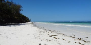
- Marenga Beach (5 km west): A favorite for locals and visitors alike — golden sands, gentle waves, and palm-lined tranquility. Sunset views here rival any along the Kenyan coast.
- Budalang’i Delta: South of Marenga lies the vast floodplain where River Nzoia meets Lake Victoria. It’s an ecological spectacle — papyrus, hippos, crocodiles, and the rhythmic dance of fishermen casting nets from canoes.
- Bunyala Rice Scheme: Set inland, this large irrigation project transformed Busia’s economy. The golden rice paddies, when viewed from above, shimmer like a green-gold mosaic.
- Yala Swamp: East of Port Victoria, this wetland extends toward Siaya County — one of Kenya’s key birding destinations, home to the papyrus gonolek and sitatunga antelope.
- Sio Siteki Swamp: Linking the Sio River and Yala wetlands, this is a lesser-known but rich wetland corridor for migratory species, offering a meditative stop for nature photographers.
4. Northern Highlands: Rocks, Sanctuaries, and Stories
Heading northwards, from Busia Town toward Malaba and Teso (70–120 km total loop)
- Kavirondo Rocks: Towering granite domes east of Nambale, reminiscent of miniature inselbergs. These rocky outcrops form an ancient landscape sculpted by time, with impressive balancing stones that attract rock climbers and photographers.
- Emakina Hills: Rolling highlands rising north of Nambale. From their crest, the plains of Teso stretch endlessly — a countryside of millet fields and acacia-dotted savannah.
- Kakapel Rock & Cultural Centre (Teso North): A jewel of Kenya’s prehistoric heritage, Kakapel Rock Art Site features vivid paintings estimated to be thousands of years old. The nearby Kakapel Cultural Centre preserves Teso traditions through storytelling, music, and craft exhibitions.
- Malaba Sanctuary: Nestled near the Uganda border, this small forested enclave provides refuge to birds and primates. It’s a fitting finale — a tranquil stop symbolizing the balance between conservation and community life.
5. Conservation Highlight
- Muhondo Conservancy (between Samia and Port Victoria): A newer initiative promoting community wildlife conservation, sustainable fishing, and eco-tourism. The conservancy borders the Nzoia floodplain and aims to restore degraded riparian zones while creating livelihoods through beekeeping and bird tourism.
Suggested Travel Sequence (with Approximate Distances)
| Route | Distance (km) | Cumulative (km) |
|---|---|---|
| Busia Town → Alupe Leprosy Center | 5 | 5 |
| Alupe → Kocholia Irrigation Scheme | 12 | 17 |
| Kocholia → Sio Port | 28 | 45 |
| Sio Port → Samia Hills → Bakhulo Shrines | 15 | 60 |
| Bakhulo → Budalang’i Forest | 10 | 70 |
| Budalang’i → Port Victoria | 20 | 90 |
| Port Victoria → Marenga Beach → Che’s Bay Resort | 5 | 95 |
| Marenga → Budalang’i Delta → Bunyala Rice Scheme | 10 | 105 |
| Bunyala → Yala Swamp → Sio Siteki | 12 | 117 |
| Yala Swamp → Muhondo Conservancy | 8 | 125 |
| Muhondo → Kavirondo Rocks → Emakina Hills | 35 | 160 |
| Emakina Hills → Alupe → Kakapel Rock & Cultural Centre | 30 | 190 |
| Kakapel → Malaba Sanctuary | 20 | 210 |


